Friday, October 24, 2025
Home Blog Page 243

ProStar Joins Trimble’s GIS Business Partner Program to Define the Next Generation of Utility Mapping

Connected Construction Solutions

Trimble announced that ProStar has joined Trimble’s GIS Business Partner Program. As part of the program, ProStar has implemented the Trimble Precision SDK (Software Developer Kit) to integrate high-accuracy positioning capability in its PointMan mobile application running on smartphones and tablets using Trimble GNSS receivers. ProStar provides field crews with an easy-to-use mobile data collection solution designed to capture, record and provide real-time visualization of the precise locations of subsurface infrastructure while utilizing a centralized database to permanently and securely store and share utility location records in the cloud. By adding the Trimble R Series and Trimble Catalyst™ receivers to the ProStar workflow, users can confidently access high-quality data and identify potential conflicts to avoid accidents, disruption of services and costly delays to infrastructure projects impacted by not knowing the precise locations of buried utilities.

“Together, Trimble and ProStar are changing the way construction companies, engineering and surveying firms as well as government transportation agencies capture, store and utilize utility infrastructure data. By leveraging the power of geospatial technology, they are able to make more informed decisions in the field,” said Stephanie Michaud, strategic marketing manager, Trimble Survey & Mapping field solutions. “Through this collaboration with ProStar, we are committed to integrating Trimble technology into ProStar’s cloud and mobile solutions to enhance safety protocols on site, reduce project costs and make a safer work environment.”

“We’re excited about this new collaboration and the integration of our PointMan software with Trimble’s high-accuracy GNSS receivers,” said Page Tucker, president & CEO of ProStar. “Creating a seamless integration with Trimble high-accuracy receivers and our PointMan software is a game-changer that will now provide one of the most comprehensive and precise field data collection solutions in the industry.” 

Availability
Trimble R Series and Trimble Catalyst GNSS receivers are available through Trimble Geospatial Distribution Partners. For more information, visit:  https://geospatial.trimble.com/products-and-solutions/gnss-systems. PointMan software applications are available through ProStar. For more information, visit:  https://www.prostarcorp.com.

Orolia Selected by Raytheon to Support US Missile Defense System

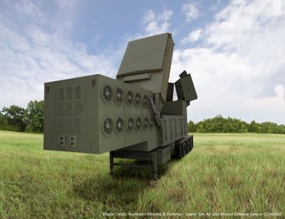
Raytheon 4488447_LTAMDS_Model

Orolia, the world leader in Resilient Positioning, Navigation and Timing (PNT), through its Orolia Government Systems business, has been selected by Raytheon Missiles & Defense to support the US Lower Tier Air and Missile Defense Sensor (LTAMDS) radar program with its low SWaP (Size, Weight and Power), rugged time and frequency system. Raytheon Missiles & Defense was selected by the United States Army in October 2019 to provide the next-generation LTAMDS, which is an advanced air and missile defense radar. The LTAMDS system will help the U.S. Army defeat advanced threats, including hypersonic weapons.

Orolia was chosen for the LTAMDS program based on its core expertise in resilient timing and configurable ruggedized PNT systems for challenging environments, together with its proven track record of successfully delivering time and frequency platforms for other Raytheon Programs of Record. Orolia was the first company to receive approval for a time and frequency reference system on the Defense Information Systems Agency (DISA) Department of Defense Information Network (DoDIN) Approved Products List for network interoperability, with its flagship SecureSync system.

“Ultra-precise mission timing and sync technology are fundamental building blocks for the Resilient PNT systems that warfighters rely on for continuous operations in contested environments,” said Hironori Sasaki, President of Orolia Defense & Security. “We are proud to be a Raytheon Missiles & Defense partner on LTAMDS and other programs that utilize GPS signals for timing, frequency and network synchronization across critical military systems.”

From critical timing solutions to GPS/GNSS simulation, interference detection, and mitigation, Orolia is the industry leader in end-to-end NAVWAR and Resilient PNT solutions to protect, augment and strengthen military systems for GPS-denied environments.

Proprietary ISO 15765 Protocol Stack Enables Advanced Analytics in On-Board Diagnostics and Telematics Control Units

I Wave

With an increased demand for advanced analytics in CAN-based vehicles and a growing requirement for analytics on the edge, iWave has developed a proprietary ISO 15765 stack, enabling a simple and customizable API for handling diagnostics data over the ISO 15765 CAN network. ISO 15765 is an international standard and is the most widely used communication protocol in passenger and commercial vehicles since 2008.The protocol defines exactly how messages are exchanged in a vehicle’s interconnected ECU system.

The ISO 15765 stack developed by IWave, based on ANSI C source code inherently supports all the specifications of ISO 15765 protocol, in addition to the extended four variations of ISO 15765-4 CAN. The stack supports both 29-bit and 11-bit CAN identifiers with standard baud rates of 250 kbps and 500 kbps, allowing the device to interpret all ISO 15765 standard messages from Vehicle ECU. The stack effectively determines the underlying ISO 15765-4 CAN supported by the vehicle and initiates communication to receive and decode the data frames. 

We enable full customization of the stack, integrating customer specified feature sets and fine-tuning to meet end application requirements. Our comprehensive software development solutions involving protocol stack development, integration, optimized configuration tuning and application development ensures faster deployment and time to market of the OBD II solution.

With the ISO 15765 protocol stack, the OBD II device can communicate directly with the vehicle and retrieve critical parameters specified by the manufacturer. Parameters such as speed, engine data, and emission data obtained in the form of Diagnostic Trouble Codes (DTC) are decoded and sent to customer specified Cloud-based applications for analysis. Any rare occurrences /defects can be easily detected by analyzing the codes, thereby enabling efficiency in the vehicle’s remote management and overall performance.

The following are the key features of OBD II ISO 15765 CAN Stack:

  • Based on ANSI C source code
  • Supports four variants of ISO 15765-4 CAN
  • Supports Multi-frame message filtering
  • Customizable stack features
  • Provide access to retrieve manufacture specific vehicle data

In addition to ISO 15765 protocol stack, iWave OBD II device supports the SAE J1939 protocol stack allowing high speed communication and diagnostics of data from heavy-duty vehicles.

More details about iWave Telematic offerings can be found here .

SpaceX Launched US Space Force’s SV03 GPS III Satellite

GPSIII

SpaceX (Space Exploration Technologies Corporation) an American aerospace manufacturer and space transportation services company successfully launched Falcon 9 rocket with Space Vehicle 03 (SV03), the next generation third Block III Global Positioning System (GPS) satellite for the US Space Force on Tuesday, 30th June 2020. The taking off was from Space Launch Complex 40 (SLC-40) at Cape Canaveral Air Force Station (Florida) at 4:10 p.m. EDT (2010 GMT).

GPS III SV03 is the 9,505-pound (4,311-kilogram) satellite which is designed by Lockheed Martin Space Systems. It is the third model of its series replacing the previous Block II series with this upgraded version of GPS satellite. It is the third USSF mission launch, second National Security Space launch (NSSL) mission on SpaceX’s Falcon 9 rocket and the first mission where the service provider of a launch aim to recover the booster.

GPS III is considered as the most powerful GPS Satellite bringing a new level of distinction or supremacy for the entire space community. Medium Earth Orbit (MEO) Space Systems Division chief, Col. Edward Byrne said, “The GPS III program continues to build on its successes by delivering advanced capabilities for the United States Space Force, and maintaining the “gold standard” for position, navigation and timing.”

The launch program had been the continuous efforts by the Defence Department to upgrade the current GPS satellites in space. GPS III will operate alongside the constellation of currently operating 31 GPS satellites of United States and would benefit users to connect with more satellites in space with better accuracy.

Here are some key highlights of GPS III-03 :

  • More accurate (three times) and powerful signals than previous GPS satellites enabling higher throughput and availability.
  • Benefiting 4 billion global users through better signals and more capability.
  • Improved navigational performance for military and civilian users.
  • Enhanced Military code (M-Code) capable satellite showcasing spot beam capability for more accurate and secure military signals.
  • Eighth times (8X) improved anti-jamming capabilities.
  • Powerful new regional military protection and full digital navigation payload.
  • An accuracy-enhancing array with search and rescue payload.
  • Feature of control architecture and a cross-linked command for updating the entire constellation from a single ground station.
  • 15 years operational design life for being in orbit for longer run than predecessor GPS satellites.
  • Transmitting power of 500 times than earlier systems of GPS.
  • New L1C civil signal GNSS compatibility interoperable with Europe’s Galileo Constellation and other GNSS systems.
  • Additional broadcast frequencies for more interoperable of GPS network with other navigation satellites fleets.
  • Position accuracy of 0.63 m and designed for an orbit more than twelve thousand miles above the earth.
  • Based upon the modular framework of Lockheed Martin’s tried-and-true A2100 “bus” that supports electricity of Fifteen kilowatts.
  •  Designed in a virtual reality environment to maximize efficiency and streamline production.
  • Compatible with Air Force’s next generation ground control system and the current GPS constellation.
  •  Designed to provide the air force flexibility, to meet evolving mission needs and to incorporate new technology.

KVH Launches Inertial Sensor with Photonic Chip Technology

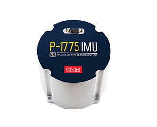
KVH Launches Inertial Sensor with Photonic Chip Technology

KVH announced the P-1775 inertial measurement unit (IMU) featuring KVH’s new PIC Inside photonic integrated chip (PIC) technology is now available and the first units have started shipping. KVH has been developing and testing the technology for more than three years and is now incorporating it into existing product lines. One of the first customers has integrated the P-1775 IMU with PIC Inside into their next-generation rocket launch vehicle.

KVH’s PIC Inside technology features an integrated planar optical chip that replaces individual fiber optic components to simplify production while maintaining or improving accuracy and performance. The PIC Inside product is designed to deliver 20 times higher accuracy than less expensive MEMS inertial measurement units, uses modular designs for ease of integration, and has outstanding repeatability unit-to-unit.

“I applaud the tremendous effort by our incredible engineers in developing this groundbreaking technology and I am thrilled that we have begun to incorporate PIC Inside technology into our existing products, a process that we expect to continue throughout the year,” says Martin Kits van Heyningen, KVH CEO.

The PIC technology will be added to KVH’s inertial sensor product line for use across a broad range of applications from navigation to stabilization and pointing. KVH’s fiber optic gyros (FOGs) and FOG-based products are particularly well-suited for the large and growing autonomous market. This market includes applications on land, sea, and air, such as drones, people movers, trucks, and mining and construction equipment.

Autonomous applications rely on high quality inertial sensors to deliver an extremely accurate navigation solution, delivering the performance required in critical metrics such as angle random walk (ARW) and bias instability. Next-generation driverless cars, which require centimeter-level precision for safety, are the ideal application for KVH’s inertial products. Employing the PIC design allows for a lower cost and scalable solution due to the elimination of various fiber components and a reduction of labor.

Last year, KVH announced that it had delivered its first product prototypes containing PIC technology to leading automotive customers and presented the science behind the technology to an audience of engineers at a leading inertial sensor conference, describing the extensive development, testing, and benefits of the new technology.

KVH is a leading innovator for assured navigation and autonomous accuracy using high-performance sensors and integrated inertial systems. KVH’s widely fielded TACNAV systems are currently in use by the U.S. Army and Marine Corps as well as many allied militaries around the world. KVH’s FOGs and FOG-based IMUs are in use today in a wide variety of applications ranging from optical, antenna, and sensor stabilization systems to mobile mapping solutions and autonomous platforms and cars.

BX40C RTK, A Compact GNSS Board with Full Constellation Tracking

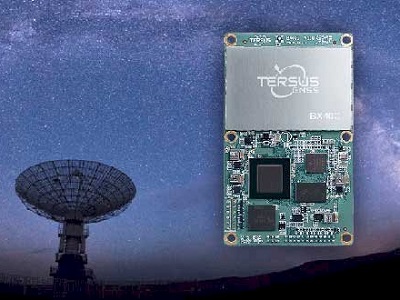
BX40C RTK, A Compact GNSS Board

Tersus announced the BX40C RTK Board to support its series of GNSS boards and provide high accuracy, fast positioning services. Powered by new Tersus ExtremeRTK GNSS Technology, the BX40C Board can support multi-constellation and multi-frequency all-in-view satellite tracking.

“Tersus has been proud of its BX-series RTK boards, and today we added a new member to the series by launching the new BX40C Board. The BX40C is with enhanced positioning accuracy and constellation tracking, even in harsh environments, the BX40C Board can still control deviation within 3cm in surveying&mapping applications,” said Xiaohua Wen, Founder&CEO of Tersus GNSS Inc. “BX40C supports 576 channels and can achieve centimetre-level position accuracy easily. We are excited to see how BX40C strengthens our product portfolio and technology competence to make a great effort in this industry.”

The Tersus BX40C is a compact GNSS RTK board with full constellation tracking for providing cm-level accuracy positioning. It can be integrated with autopilots and inertial navigation units to meet various developing requirements. It is ideal for high-precision positioning, navigation, and mapping.

The BX40C board supports multiple constellations and multiple frequencies to improve the continuity and reliability of the RTK solution even in harsh environments. In-built 4GB memory makes data collection easy. It features compatibility with other GNSS boards in the market via flexible interfaces, smart hardware design, and commonly used log/command formats.

For more product information about BX40C RTK Board, please click here.

Septentrio launches mosaic-T, highly secure & accurate GNSS timing

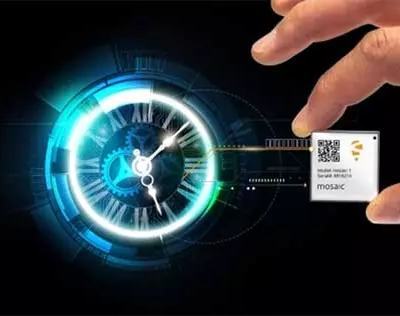
Septentrio launches mosaic-T

Septentrio announces an addition to its GNSS timing portfolio: mosaic-T is a high-end GPS/GNSS receiver module built specifically for resilient and precise time and frequency synchronization under challenging conditions. Its multi-frequency multi-constellation GNSS technology together with AIM+ Advanced Interference Mitigation algorithms allows mosaic-TTM to achieve maximal availability even in the presence of GNSS jamming or spoofing**. This compact surface-mount module is designed for automated assembly and high-volume production.

“We are excited to expand our mosaic GNSS module family with mosaic-T, which will provide critical infrastructure and mission-critical PNT applications with accurate, reliable and resilient timing solutions”, commented Francois Freulon, Head of Product Management at Septentrio.

Septentrio mosaic-TTM delivers timing with nanosecond-level accuracy and has additional inputs for an external high-accuracy clock. Its small form factor offers an easy-to-integrate robust solution for any mission-critical timing application.

SBG Systems present 3rd generation miniature inertial sensors for GNSS receiver

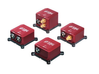
3rd generation miniature inertial sensors for GNSS receiver

SBG Systems is the only manufacturer of miniature to high accuracy inertial navigation systems mastering the Inertial Measurement Unit design, calibration, and filtering. All improvements made in the high-end lines could naturally benefit to the Ellipse miniature line.

High-end INS Technology in the Smallest Form Factor

The company is proud to present the third generation of its popular range of miniature inertial sensors called the Ellipse Series. The line is composed of four models: the Ellipse-A is a motion sensor, the Ellipse-E provides navigation with an external GNSS receiver, the Ellipse-N is a single antenna RTK GNSS/INS and the Ellipse-D is a dual-antenna RTK GNSS/INS. With its new 64-bit architecture, the Ellipse Series 3rd generation enables the use of high precision algorithms and technology used in high-end inertial systems such as rejection filters, FIR filtering, etc. All Ellipse miniature INS are now RTK-enabled without extra cost and output raw data for post-processing. All these features are made possible in small and robust aluminum enclosure box version, but also in the 17-gram OEM version providing unmatched performance/size ratio.

Smallest Dual-frequency, Dual-antenna RTK GNSS/INS

Whether you choose the box or the OEM version, get the best performance/price/size ratio with the new Ellipse-D. With its dual frequency RTK GNSS receiver, the Ellipse-D provides a centimetric position. Dual frequency provides a way more robust heading and position computation than single frequency receivers. It allows unmatched performance in attitude (0.05°) and in heading (0.2°). With its dual-antenna capability, Ellipse-D provides precise heading in a few seconds, in all dynamic conditions, and even in challenging GNSS conditions. It is also immune to magnetic disturbances. Ellipse-D is quad-constellation, meaning it could use simultaneously satellites from GPS, GLONASS, BEIDOU, and GALILEO for more signal availability in challenging navigation conditions.

The Most Reliable Miniature Inertial Sensors

Robustness and reliability has always been at the core of the Ellipse Series. Designed with high quality industrial-grade components, Ellipse inertial sensors are highly tested and calibrated in dynamic and temperature for a consistent and repeatable behavior in all conditions. Highly trustworthy, the Ellipse Series is the only miniature inertial sensors coming with a two-year warranty.

Airbus signs contract for integration of 115 new Eurofighter ESCAN radars

Airbus has been awarded a contract for the development, supply and integration of 115 Eurofighter ESCAN Radars for the German and Spanish Eurofighter fleet. It marks the so far largest order for the world’s most modern electronically scanned array radar, Captor-E. The contract signature followed the approval by both governments in recent weeks.

The contract foresees the delivery and integration of 110 Captor-E radars for Germany and an initial batch of 5 radars for Spain to be delivered by 2023. The new sensor will equip Tranche 2 and Tranche 3 Eurofighters as well as new aircraft. Whereas the Airbus sites in Manching, Germany and Getafe, Spain will act as overall integration Hub, the development and building of the radar will be subcontracted to a consortium under the leadership of Hensoldt and Indra and by participation of further Eurofighter partner companies.

“The contract for the Captor-E radar is a main achievement to equip Eurofighter with sensors that ensure todays dominance of the aircraft also in the threat scenarios of tomorrow”, said Dirk Hoke, CEO of Airbus Defence and Space. “With Eurofighter, Germany and Spain are investing in a strong backbone of European air defence and in the leading project of the European defence industry.”

Eurofighter Captor-E is the world’s most advanced electronically scanned array radar for fighter aircraft. The design of the front fuselage airframe allows Eurofighter to deliver the largest electronically scanned array for increased detection and tracking ranges, advanced Air-to-Surface capability and enhanced electronic protection measures. The large antenna surface also allows a wider field of regard than any other platform pushing the aircraft’s performance and guaranteeing its role as a valuable asset within the Future Combat Aircraft System environment.

The signed contract will also give an additional push to the export tenders Eurofighter is currently bidding for.   

Smart Agriculture through GPS Technology

GPS Technology in Agriculture

GPS Technology in Agriculture is revolutionising the farming practices while providing many benefits & various opportunities to farmers

Global Positioning System (GPS) has always ranked high in the field of navigation system and has provided numerous applications to different industries. One such is the agriculture industry which is revolutionising with the use of digital technologies in farming such as drones, remote monitoring, sensors and GPS technology in farming practices.

GPS system provides many benefits and various opportunities to farmers for effective farming practices, crop maintenance and production of good quality of crops by monitoring and eliminating pathogen affected areas through early treatment.

GPS help farmers to continue their work accurately during low visibility field conditions such as night and dirt. It helps in navigating the particular location in the field, collecting the samples of soil, identifying the accurate areas of the field or any tree affected by pathogen to prevent the damage.

The technology has not only gained importance in the field of Precision farming and Site-specific farming but has also helped farmers to monitor the crop health at different stages of its development process in different weather conditions.  Here are some of the uses of GPS technology in agriculture –

  • Creating yield maps: GPS data is used to create the yield map which helps in comparing the yield distribution every year within a field and thus help farmers to examine the areas that are not yielding any crop or those which require more irrigation. The data also analyse the content of moisture in a field.
  • Sampling of soil: GPS along with mapping software helps in organizing the collected soil samples from fields. This data is used to determine the properties and conditions of soil which gives the information that whether a soil is fit for a particular type of crop or not. It also help in the optimal use of fertilizer and pesticides and control pollution.
  • Tractor guidance: The RTK GPS for tractor acts as a manual guidance system for it. Ploughing a field with a recording GPS system enable in programming a tractor to follow the same route for cultivation, harvesting and spacing required between the crops.
  • Weed Location: Weed hinders the growth of a plant. The GPS system help in the growth of a crop by determining weed location through the technique of linear sampling.
  • Developing tools: GPS equipped tools with programming improve farming activities and help agribusiness to become more efficient and productive.
  • Determining harvesting: GPS has a major role in determining harvesting as it helps in estimating the size of area to be harvested and how it will take place.
  • Accurate planting: With the help of GPS, planting can be done accurately as it tells the depth and spacing required for a seed to be planted.
  • Tracking Livestock: GPS transmitters attached to animals collar help in tracking their location on large farms.
  • Cropduster targeting:  GPS records the location of areas affected by pathogen and insects problems. The data help Cropduster pilots to selectively target the affected areas instead of treating an entire field as a result saves time and control exposure of chemicals.