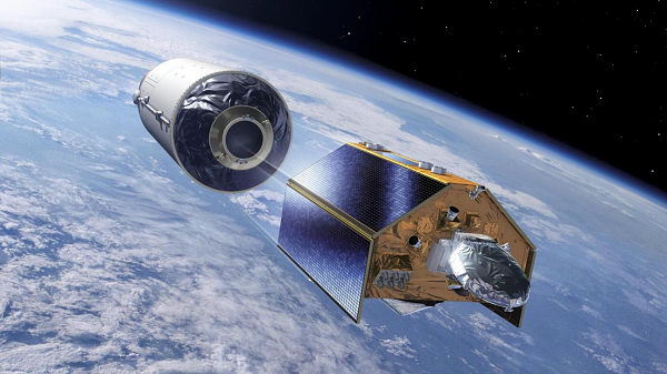
The Copernicus Sentinel-6B Earth-observation satellite has successfully been launched from the U.S. Vandenberg Space Force Base (VSFB), California, by a Falcon 9 vehicle operated by SpaceX.
Thales Alenia Space, the joint venture between Thales (67%) and Leonardo (33%), supplied the Poseidon-4 radar altimeter and the S-band TT&C transponders for Sentinel-6B, built by Airbus Defence and Space as prime contractor for the European Space Agency (ESA). The Sentinel-6 mission is part of Copernicus, the Earth-observation component of the European Union’s Space Programme, and the result of a unique collaboration between the European Commission, ESA, Eumetsat, NASA and NOAA, with support from the French space agency CNES.
For one year, Sentinel-6B will orbit in tandem with Sentinel-6 Michael Freilich, launched in November 2020, to calibrate the two missions before taking over from its predecessor. This gold-standard radar altimetry mission will ensure continuity of sea level data through to at least 2030.
With 10% of the world’s population living less than 10 meters above sea level in coastal communities, sea level rise is one of the main concerns relating to Earth’s changing climate. The global level of oceans is currently rising at an average rate of 3.3 millimeters a year, a rise that has accelerated in recent years, potentially spelling dramatic consequences for these populations.
Like its twin Sentinel-6 Michael Freilich, Sentinel-6B is carrying the Poseidon-4 altimeter developed by Thales Alenia Space. This highly precise radar altimetry technology measures ocean topography every 10 days with sub-centimeter accuracy.
Ocean topography is a critical indicator in surveying climate change as well as ocean dynamics, currents, wave height, and surface wind speed. Precise and continuous monitoring of sea level is crucial to acquire reliable data informing effective climate policies for governments and institutions, and to protect the millions of people under threat from sea level rise. Such data is also invaluable for emergency responders in the event of a disaster, and for departments in charge of urban planning, building safety, and levee management.
“I’m delighted to see this successful launch of the Sentinel-6B satellite, which will ensure continuity of high-precision ocean topography data vital for surveying climate change and protecting coastal communities,” said Hervé Derrey, President and CEO of Thales Alenia Space. “Thales Alenia Space’s teams, who have been instrumental in the success of satellite altimetry missions from the outset, can be proud of this latest achievement reflecting the excellent international collaboration in space oceanography.”
With a launch mass of around 1.2 metric tons, Sentinel-6B will operate in low Earth orbit at an altitude of 1,336 km and has a design life of 7 years.
Thales Alenia Space, a key Copernicus partner
Thales Alenia Space is a major contributor to 11 of the Copernicus program’s 12 missions. Sentinel-1 monitors land surfaces and seas in all weather conditions, day and night, thanks to its radar capabilities. Sentinel-2 and -3 acquire high-resolution optical imagery over land and coastal waters. Sentinel-4 and -5 are dedicated to meteorology and climatology missions. Sentinel-6 surveys the planet’s oceans. As well as being prime contractor for the Sentinel-1 and -3 satellite families, Thales Alenia Space also supplied the Sentinel-2 image ground segment and helped build the imaging spectrometer on Sentinel-5P and the Poseidon-4 radar altimeter on Sentinel-6. In 2020, Thales Alenia Space was awarded five contracts for the six new Copernicus Expansion missions, as prime contractor for the CIMR, ROSE-L and CHIME satellites, and supplier of the CRISTAL and CO2M mission payloads. These new satellites will measure human-induced atmospheric carbon dioxide, survey sea ice and snow cover, support new optimized services for sustainable farming and biodiversity, observe sea-surface temperature and salinity as well as sea-ice density, and strengthen land-monitoring and emergency management services.
Thales Alenia Space’s Toulouse facility is the world leader in satellite altimetry for Earth observation
This is where the company has built:
• The Poseidon altimeters (1 to 3) on the TOPEX/Poseidon, Jason and SWOT missions for CNES.
• The Poseidon-4 digital altimeter on ESA’s Sentinel-6 mission.
• The AltiKa Ka-band altimeter for the French-Indian SARAL oceanography satellite.
• The SIRAL 2 very-high-resolution synthetic aperture radar altimeter for ESA’s CryoSat-2 satellite, capable of measuring variations in sea-ice thickness and changes in the land ice mass balance with unrivaled accuracy.
• The SRAL altimeters on Sentinel-3.
• The SWIM wave spectrometer on the CFOSat satellite for CNES, designed to measure wave spectra while also performing an altimetry function.
• The RFU (radiofrequency unit) for the KaRIn wide-swath altimeter and the Poseidon-3 Nadir altimeter for the French-U.S. SWOT mission, launched in 2022, a key step forward as the first wide-swath altimetry mission capable of acquiring a two-dimensional picture of water height from two 60-km swaths on either side of the satellite track, supplying unprecedented data on the world’s oceans, precise measurements of surface waters (rivers and lakes), and the ability to scan nearer coastlines.
• The IRIS altimeters for the Copernicus CRISTAL mission under development to survey sea and land ice.
• The wide-swath and nadir altimeters for the Sentinel-3 New Generation program currently in the design phase for ESA.
The birth of satellite altimetry and programs in partnership with CNES
The feasibility of acquiring precise and continuous measurements of ocean surface topography from space was first explored by the U.S. Geosat and Seasat missions. NASA and CNES subsequently joined forces to develop and further satellite altimetry, giving rise to the TOPEX/Poseidon mission, with the very ambitious aim of acquiring global coverage of the oceans with centimeter accuracy. The first Poseidon altimeter was the culmination of a seven-year joint effort on the part of CNES and Thales Alenia Space’s teams in Toulouse. The TOPEX/Poseidon satellite began its mission in 1992 and was immediately successful, paving the way for a 30-year partnership between CNES and NASA. Thales Alenia Space has been integral to these outstanding programs from the outset, in particular building the radar altimeter instruments for all subsequent missions: Jason 1 (carrying the Poseidon-2 altimeter), Jason-2 (Poseidon-3A), Jason-3 (Poseidon-3B) and more recently SWOT (Poseidon-3C and a wide-swath altimeter).


