Sunday, October 26, 2025
Home Blog Page 241

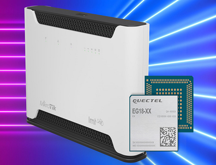
Quectel EG18 module supports MikroTik & LMT LTE18 router

MikroTik LMT LTE18 router.

Quectel’s EG18 LTE-Advanced Category 18 Qualcomm-based module is implemented in new LTE18 router from MikroTik and LMT that incorporates the latest generation cellular technologies to provide faster internet for connected devices.

The Quectel EG18 delivers 1.2Gbps downlink and 150Mbps uplink peak data rates and enables download and use of up to 5 frequencies simultaneously, with uploads on up to 2 frequencies. The maximum download speed provided by the router is 1.2 Gbps, and the upload speed is 150 Mbps. The module also supports MIMO 4×4 and the device has four antennas that connect to the base station, resulting in a more stable internet connection.

The MikroTik LMT LTE18 router is intended for customers with high data consumption, who regularly use the internet connection not only on a computer or a phone, but also on other devices, such as game consoles, smart TVs or area surveillance cameras. The router is also suitable for operators who use specific virtual private network (VPN) connections, as well as provide public internet access to their customers or local network users, because the router’s operating system also provides Hotspot functionality and a wide range of specific configurations. The router meets the highest security standards and has potential for export to other markets.

LMT, together with its partners, is working on the development of the 5G network as well as the design of new products and solutions to enable full use of the advantages and opportunities provided by 5G in the future,” said Juris Binde, the president of LMT Innovations. “Working closely with the domestic ICT industry giant MikroTik, we have jointly created an innovation laboratory, which has already produced 4G routers and prototypes of 5G routers. Several other solutions are under development, and a high-capacity data transmission network for Latvian research institutions with a speed of 10 Gbps has just been jointly established, which facilitates the work of scientists.”

John Tully, co-owner and chairman of the board of MikroTik, added: “Everyone understands that 5G will bring not only unprecedented data speeds, but also millions of sensors, smart devices, devices and automated solutions that will work in this network,” he said. “Therefore, while designing this router together with LMT Innovations, we kept in mind not only the current technological needs of internet users, but also how they will change in the near future; 5G capabilities will become more and more available in every sphere of life. For this reason, the MikroTik LMT LTE18 router has expanded functionality that will satisfy both business customers and any household requirements, not only now, but also in the foreseeable future.”

Dominik Hierl, SVP Sales EMEA, Quectel Wireless Solutions, commented: “We’re delighted that MikroTik and LMT have selected our innovative EG18 module to support high data consumption users for the new MikroTik LMT LTE18 router. We look forward to working with the companies as the router is rolled out to customers in Latvia and in other markets in the future.”

C1 GNSS RTK OEM receiver at $139 ready for massive GNSS market

C1 GNSS RTK OEM receiver

Due to the complexity of differential correction service infrastructure and high cost of GNSS receiver hardware, the GNSS RTK technology has been used just in traditional low-volume markets such as surveying and mapping, but not in many emerging high-volume markets such as autonomous vehicles, V2X and robotics. This situation will be definitely changed by technological progresses. In addition, there are currently more than 100 satellites that can be tracked and used from all four GNSS constellations (GPS, GLONASS, Galileo, and BeiDou which was just announced recently by China to provide global services). Moreover, it will not be just a dream that the 5G data will carry RTCM correction data as well in the near future, according to China Mobile, the world’s largest mobile operator.

The GNSS high precision positioning market has reached a time of transition.

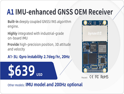
Bynav (Hunan Bynav Technology Co., Ltd.), a leading supplier of GNSS high precision positioning receivers in Chinese vehicle driver testing application market, officially released the C1 GNSS RTK OEM receiver and the A1 industrial-grade IMU-enhanced GNSS OEM receiver based on Bynav GNSS baseband ASIC Alita and RFIC Ripley.

The C1 GNSS RTK OEM receiver board measures 46×71mm and supports dual-antenna heading and full-constellation, including GPS, BDS, Galileo, GLONASS, QZSS, NavIC and SBAS with the RTK position accuracy 1cm+1ppm RMS, as well as providing enhanced interfaces like UART serial port, Ethernet, 3 EVENT_IN, 3 EVENT_OUT, 1PPS, CAN bus for easy integration with external IMU, odometry, LiDAR or visual SLAM.

The A1 GNSS/INS OEM receiver, measuring 46×71mm and weighing 25g, is highly integrated with an industrial-grade IMU (gyro 2.7deg/hr) with an embedded deeply coupled GNSS+INS algorithm engine as well as tilt measurement algorithm to provide stable, high precision position and attitude even in the event of GNSS outages.

As a strategic partner of Duolun Technology, China’s top1 vehicle driver testing system integrator, thousands of drivers testing vehicles equipped with Bynav GNSS RTK receivers are running around China every day.

The performance of the A1 and C1 have been verified and recognized by many domestic customers in the field of vehicle driver testing and autonomous driving.

Ying Long, deputy general manager of CIDI (Changsha Intelligent Driving Institute), a well-known autonomous driving company in China, commented, “We are committed to developing intelligent driving vehicles and commercializing them as soon as possible, in which the GNSS/INS receiver plays an important role to provide absolute position. That’s why I started work together with Bynav for a cost-effective and high-performance positioning solution. Currently the Bynav’s GNSS/INS receivers have been used in our unmanned sweepers, self-driving trucks and other products, and it comes out that the A1 performance is comparable to the world-class and high-end products we used.”

Currently both C1 and A1 are available for direct purchase. For wholesale price, please contact en@bynav.com.

To get more product information, please check bynav official website here.

TomTom to Supply Maps, Navigation Software & Connected Services for New Maserati Models

TomTom’s global deal with Maserati to provide maps, navigation software and connected services for the all-new Maserati Intelligent Assistant (MIA) in-vehicle infotainment system including the MC20 Supercar. Drivers of upcoming Ghibli, Levante and Quattroporte models will be the first to benefit from a wide range of innovative features provided by TomTom, including: IQ Maps, traffic, connected navigation services, destination prediction, and a premium user interface. The Ghibli, Levante and Quattroporte will hit the road in October, whilst other models like the recently unveiled MC20 supercar will follow in 2021.

We are delighted that our premium navigation will now power Maserati’s exclusive sports cars,” said Antoine Saucier, Managing Director, TomTom Automotive. “Maserati drivers will benefit from seamless connectivity and automatic over-the-air map updates so they can get in and get going.”

The MIA in-vehicle infotainment system includes the full array of TomTom’s traffic and connected navigation services. This includes TomTom EV Services showing charging points and their availability for Maserati’s upcoming electrified Folgore range, slated for 2021. New to Maserati cars, dynamic range mapping will help drivers to visualize the vehicle’s range by displaying how far they can drive on their map. If the car’s battery or fuel is insufficient to make it to the selected destination, the driver will be prompted via an onscreen warning to navigate towards a charging point or fuel station. The driver will be provided with a cost comparison of available recharging /refueling stations that are within range.

Destination prediction is also a new feature that enables the system to learn when it is time to prompt the driver with guidance towards one of the user’s favorite places.

We want Maserati drivers to get in their car and focus on their driving experience,” said Theo-Han Jansen, Head of e-Mobility and Connectivity at Maserati. “TomTom’s new navigation with integrated voice control allows for a seamless and safe experience.”

TomTom’s integrated solution will be displayed across both the center console and cluster screens, featuring a premium TomTom user interface customizable to the driver’s personal preferences. This integrated approach means the MIA system can project moving lane and turn-by-turn guidance, as well as speed camera, traffic and hazard warnings to the vehicle’s cluster screen. This feature reduces lateral head movement so drivers can focus on the road for a smooth and safer drive.

For more information visit : www.tomtom.com

Full-band & Triple-band GNSS Antennas for high-precision applications

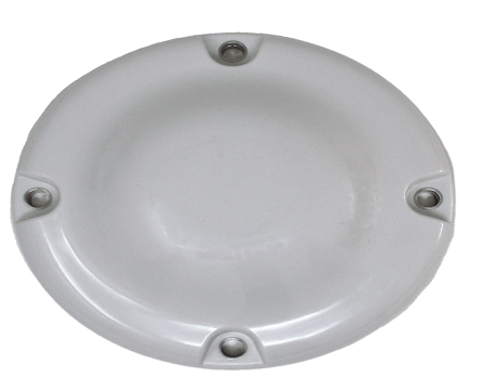
Full-band and Triple-band-GNSS-Antennas.

Tallysman Wireless introduces a Full-band and Triple-band VeroStar GNSS Antennas products which are compact and lightweight surface mount VeroStar models with unique key features that are not available on other antennas.

The lightweight (340 g) and compact wide-band spherical antenna element enables the VeroStar to deliver a ±2 mm phase centre variation (PCV), making it ideal for high-precision applications, such as precision agriculture, autonomous vehicle navigation (land, sea, and air), and maritime positioning.

The full and triple-band surface-mount VeroStar antennas are designed and crafted for high-accuracy positioning. With an exceptionally low roll-off from zenith to the horizon, VeroStar antennas provide the best-in-class tracking of GNSS and L-band correction signals at low elevation angles. Also, the optimized axial ratio at all elevation angles results in excellent multipath rejection, thus enabling accurate and precise code and phase tracking. Additionally, VeroStar antennas feature a robust pre-filter and high-IP3 LNA architecture, minimizing de-sensing from high-level out-of-band signals, including 700 MHz LTE, while still providing a noise figure of only 1.8 dB.

The VSS6037 supports the full GNSS spectrum, while the VSS6337 supports the GPS/QZSS-L1/L2/L5, GLONASS-G1/G2/G3, Galileo-E1/E5a/E5b, BeiDou-B1/B2/B2a, and NavIC-L5 signals and frequency bands. The VSS6037L and the VSS6337L also include support for L-band correction services.

The unique features of the VeroStar antennas guarantee it can deliver high signal-to-noise ratio (SNR), high accuracy, and high precision in the most challenging environments.

Sensonor launched Gyro and IMU Modules for Space

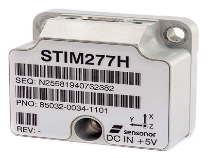
Gyro and IMU Modules

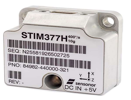
Sensonor launches the tactical-grade STIM277H Gyro and STIM377H Inertial Measurement Unit modules which are a good fit for satellite attitude & orbit control systems (AOCS), launchers, portable target acquisition systems, UAV payloads, land navigation systems, turret stabilization, missile stability and GNSS supported navigation systems.


The modules have a hermetic aluminum enclosure with a glass-to-metal sealed electrical micro-d connector and a laser-welded lid to secure long-term hermetic operation. All parts are tested for fine and gross leak to conform to MIL-STD-883J, Class H.


The hermetic enclosure protects the system from the external environment and ensures long-term reliability to meet requirements within the space segment and other applications needing exceptional long-term reliability. The design is tested for a 20+ years’ operating life through high-temperature operating life (HTOL)
testing.


STIM277H and STIM377H are electrically and mechanically backward-compatible with Sensonor’s other IMU and gyro modules, and provide users with an easy implementation into an existing design.


The components come in dust-free clean-room packaging and have SurTec650 as the only surface treatment. The components are International Traffic in Arms Regulations (ITAR)-free, and have a range of features that can be configured by the customer.


While the new part is still a commercial off-the-shelf (COTS) product and not space-qualified, Sensonor has carried out extensive radiation characterizations to understand the capability of the parts. This data is available on request from Sensonor or can be downloaded from https://digitalcommons.usu.edu/smallsat/2019/all2019/117/


The parts are a good fit for satellite attitude & orbit control systems (AOCS), launchers, portable target acquisition systems, UAV payloads, land navigation systems, turret stabilization, missile stability and GNSS supported navigation systems.


STIM277H and STIM377H are available for ordering. Detailed product specifications are available at www.Sensonor.com

Tecnobit – Grupo Oesía and UAV Navigation collaborates for unmanned aerial systems

unmanned aerial systems

Tecnobit – Grupo Oesía and UAV Navigation have signed a framework agreement for strategic collaboration to enhance their range of solutions for unmanned aerial systems (UAV) with the aim of strengthening the technological capabilities of both Spanish companies.

The industrial and technological cooperation derived from this agreement will serve to reinforce the Spanish contribution to large, European Future Air Systems Programs such as NGWS/FCAS, SIRTAP, EUROMALE and Future Trainer.

Due to its relevance to the European cooperation framework and its economic importance, it is worth highlighting the impact of the agreement reached in the NGWS/FCAS project, where a significant improvement is obtained in the positioning of Tecnobit-Grupo Oesía and UAV Navigation in the project, which they have to date approached independently.

Both companies are complementary in the value chain and in the commercial process. The capabilities of UAV Navigation, a company expert in specific areas such as guidance, navigation and control of unmanned aerial vehicles (UAVs), combined with those of Tecnobit – Grupo Oesía, will enable a substantial improvement in the technological solutions which together they can provide, covering areas that up to now they had not been able to address separately, whilst also significantly expanding their product offerings in the aerospace market.

In this way, both companies see an opportunity to increase the value of their solutions by leveraging their diverse capabilities and will create new, more competitive products. They will also collaborate for business development and throughout the product lifecycle, addressing new opportunities.

The signing of this strategic collaboration framework agreement is a source of satisfaction for both Tecnobit – Grupo Oesía and UAV Navigation and represents another step in the realization of their vision of being increasingly relevant players in the development of the Spanish aeronautical industry. Together they aim to identify positioning opportunities based on knowledge, whilst maximizing their participation in multinational cooperation programs, thereby contributing to the objectives set by the Spanish Ministry of Defense.

Tecnobit – Grupo Oesía contributes its extensive experience in the aerospace sector, having been a provider of on-board electronic systems for European programs such as Eurofighter for 28 years, and an international reference in communications and signal processing (sensors, data links, displays). The areas of collaboration encompass Integrated Modular Avionics (IMA), autonomous, distributed and predictable decision making; highly automated and dynamic mission task planning and mission task re-planning; Detect & Avoid technologies; new concepts and innovation in swarm and formation flight; advanced flight control system and UAV autopilots; navigation in GNSS-denied environments and miniaturized payload system integration

Safran’s Euroflir 410, airborne electro-optical systems selected for H160 helicopters

Babcock France, an engineering firm that provides support services for government strategic forces, has selected the new-generation Euroflir™410 optronic (electro-optical) system from Safran Electronics & Defense as part of the contract awarded by French defense procurement agency DGA (Direction Générale de l’Armement) to provide four H160 helicopters to the French Navy for a period of ten years.

These four H160 rotorcraft from Airbus Helicopters will be part of an interim fleet that includes a dozen Dauphin N3 helicopters also fitted with the Euroflir™410. The H160s will be modified by Babcock to meet the French Navy’s evolving operational needs. Furthermore, feedback from the navy’s operations will be used to help design the military version of the H160, dubbed Guépard (“Leopard”).

The Euroflir™410 NG is capable of detecting a ship’s registration number or a person in distress at a distance of several kilometers. It will boost the French Navy’s operational capabilities by enabling it to carry out at-sea Search & Rescue (SAR) missions from bases in Brittany (Lanvéoc-Poulmic) and along the English Channel (Cherbourg). The EuroflirTM 410 will provide unrivaled observation capability under any conditions of visibility, in large part due to its very-long-range multispectral telescope and high-performance line-of-sight stabilization. In addition to being fitted with a high-definition video camera (HDTV) and a medium-wave infrared (MWIR) imager, its multispectral architecture also includes supplementary cameras that are particularly well suited to severe maritime environments, namely near-infrared and shortwave infrared models.

This latest contract win confirms Safran’s European leadership in the highly demanding market segment for onboard optronics. The Euroflir™410 system is designed and produced in France by Safran. The first H160 helicopters outfitted with the Euroflir™410 will be delivered in 2022. Safran also supplies Arrano turboshaft engines for the H160, along with other major equipment items.

For more information: www.safran-electronics-defense.com 

Solving the challenges of eMobility with Quectel’s dual band, multi-constellation GNSS modules

GNSS has been widely adopted as a method to track and trace large items such as ships, trucks, heavy equipment, cars and high-value freight. However, when it comes to smaller or lower value things, deployment has been constrained by the power demands of GNSS, the necessary form factor and the ability to site antennas on smaller items in ways that can enable them to track satellites effectively.

These limitations are starting to be addressed by the latest range of GNSS modules that combine small form factor and low power consumption at a pricepoint that makes them viable for integration into lower value devices. We’re not at the commodity level of tracking low value items such as small parcels but we have reached a level where small vehicles such as eScooters or eBikes can access the capabilities of GNSS.

GNSS offers the best global positioning technology solution for moving objects and that’s why car makers, for example have adopted the technology so widely. A car, though, is very different to an eScooter. Cars are expensive items so adding GNSS technology is a small incremental addition to the overall cost of a vehicle. In addition cars have unconstrained access to power from the vehicle’s systems and space requirements are not an issue. Finally, a GNSS antenna can be easily mounted on the exterior of a car or truck.

For small vehicles, like eScooters or last mile delivery robots, the opposite is true. eScooters can cost less than US$400 so additional cost has more of an impact on affordability, the vehicle’s batteries are less powerful so power demand is a consideration, and the motors and batteries leave little room for additional equipment to be integrated. In addition, the rider can present a barrier between the antenna and the satellite, obscuring the ability to connect to a constellation.

dual band, multi-constellation GNSS modules

As eMobility vehicles become more popular, suppliers have innovated to develop GNSS modules that address the limitations of deployments into smaller, lower value vehicles. However, whilst the positioning performance of GNSS can meet the eMobility industry’s needs, the deployment scenarios pose further challenges. Vibration, operation in deep urban canyons, the extremely high accuracy demanded for users to locate hire fleet vehicles and emerging regulation to geofence vehicles all place further demands on positioning capability.

For these reasons, GNSS alone can’t guarantee to provide the accuracy the eMobility industry demands. The perfect scenario, in which GNSS is an ideal positioning technology, of clear skies and no obstructions such as bridges or being left in underground parking garages doesn’t exist at all times. This means GNSS needs to be augmented by supporting technologies to achieve accurate positioning when satellites can’t be found in deep urban canyons.

There are two dimensions to achieving maximized positioning accuracy in these challenging deployments. First, maximize the possible number of satellites available to connect to by selecting a module that incudes an L1 and L5 dual band, multi-constellation GNSS receiver that can connect to a large number of satellite constellations. Second, adopt an additional technology that can provide location data from other information which can be correlated with GNSS data.

A well-established method for providing this additional information is dead reckoning. Dead reckoning combines wheel speed and inertial measurement (IMU) data with GNSS. IMU data is often composed of accelerometer and gyroscopic information which enables the location of the vehicle to be tracked. However, dead reckoning doesn’t have all the answers. Position accuracy can be affected by issues such as changes in tyre pressure which affect its circumference, road vibration and atmospheric differences.

dual band, multi-constellation GNSS modules

The limitations that affect dead reckoning mean a combination of it and GNSS data provides the most accurate and comprehensive solution for eMobility applications so precise location can be achieved more of the time.

A critical ingredient of the combined dead reckoning and GNSS solution is the GNSS receiver itself and Quectel has developed its LC79D module with receiver capability in mind to enable multiple constellations to be accessible. The GNSS receiver has an ultra-low form factor with dimensions of 10.1mm × 9.7mm ×2.4mm which suits space-constrained designs such as eMobility vehicles.

dual band, multi-constellation GNSS modules

The LC79D can track L1 and L5 bands for satellite systems including GPS, Galileo and QZSS. On the L1 band, the LC79D can track the GLONASS and Beidou satellite systems and the module tracks the IRNSS system in the L5 band. Providing both L1 and L5 capability offers huge diversity and connection choice and this coupled with dead reckoning data means eMobility companies can ensure their users and their workers can easily find their vehicles in even the most unfriendly locations.

To learn more about the positioning solutions offered for the eMobility sector and for your free copy of the Quectel GNSS whitepaper: Why GNSS for eMobility must balance precision, price, power and packaging, click here:  https://market.quectel.com/landing-page/quectel-gnss-2020/

Quectel’s new Whitepaper answers “Why GNSS for eMobility must balance precision, price, power and packaging”

dual band, multi-constellation GNSS modules

Quectel Wireless Solutions has published a new whitepaper titled ‘Why GNSS for eMobility must balance precision, price, power and packaging’. The paper details the challenges eMobility providers face in enabling vehicles such as eScooters and eBikes to be located in deep urban canyons. It examines why accurate location data will be vital in enabling the ride-sharing industry to comply with regulation to restrict eMobility usage on sidewalks and other areas.

The paper goes on to explain why adopting a GNSS module that offers a multi-constellation GNSS receiver with L1 and L5 dual band capability, significantly increases the number of satellites a vehicle can track. This capability, augmented by dead reckoning information, provides vast improvements to positioning in deep urban canyons and can achieve a 10x improvement in location accuracy.

Drive test data conducted on an eScooter in San Francisco by positioning solutions specialist HYFIX is included in the paper to demonstrate the enhanced accuracy offered by L1 and L5 plus dead reckoning capability. The paper also sets out how the Quectel LC79D is enabling the eMobility industry to harness the fusion of different sensors in a very small footprint at very low incremental cost with unparalleled accuracy.

 “eMobility providers face substantial challenges when dealing with location in deep urban environments,” said Mark Murray, VP of Sales for GNSS and Automotive at Quectel. “First and foremost, customers need to be able to find the vehicle and cities need to have the assurances that these eBikes and eScooters are operated in mutually agreed locations. This whitepaper discusses the issues faced by eMobility providers and clearly makes the case on why the LC79D is the perfect solution for this market.”

To download the Whitepaper kindly click here

R12i GNSS Receiver with Robust Tilt Compensation for Land Surveyors

GNSS Receiver for Land Surveyors

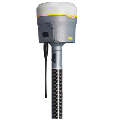
Trimble has added R12i GNSS receiver, to its Global Navigation Satellite System (GNSS) portfolio. The GNSS receiver R12i incorporates Inertial Measurement Unit (IMU)-based tilt compensation using Trimble TIP™ technology, which enables points to be measured or staked out while the survey rod is tilted, empowering land surveyors to focus on the job at hand and complete work faster and more accurately. 


The IMU-based tilt compensation capability of the Trimble R12i builds on Trimble’s unrivaled ProPoint™ GNSS positioning engine, which delivers more than 30 percent better performance in challenging environments compared to the Trimble R10-2 receiver across a variety of factors, including time to achieve survey precision levels, position accuracy and measurement reliability. Designed with flexible signal management that enables the use of all available GNSS constellations and signals, the Trimble ProPoint GNSS engine provides new levels of reliability and productivity. In addition, the ProPoint engine is a key enabler of the new TIP technology. Surveyors can continue to use the R12i’s tilt compensation functionality even in challenging environments when other solutions struggle to maintain GNSS and inertial positioning.


The Trimble TIP technology allows users to accurately mark and measure points in areas previously inaccessible for GNSS rovers such as building corners, or in hazardous situations, for example the edge of an open excavation. The receiver operates calibration-free out of the box and is resistant to magnetic interference from sources such as cars or electrical utility boxes. The R12i also features real-time automatic Inertial Navigation System (INS) integrity monitoring. This system allows users to detect and correct for IMU biases introduced by use over time, temperature or physical shocks helping ensure measurement quality and integrity for the life of the receiver.


The R12i represents Trimble’s dedication to perfecting the user experience with the industry’s best GNSS engine and now robust tilt compensation,” said Ron Bisio, senior vice president of Trimble Geospatial. “Trimble has been the leader in GNSS technology for more than 30 years and the R12i demonstrates our continued commitment to providing surveyors with the world’s most advanced and trusted GNSS systems.”


Availability
The Trimble R12i GNSS System is available now through Trimble’s Geospatial distribution channel. For more information, visit:  https://R12i.trimble.com.