Saturday, October 25, 2025
Home Blog Page 242

KVH adds 1-meter Global Marine Satellite TV Antenna for TracVision Series

newest marine satellite TV antenna

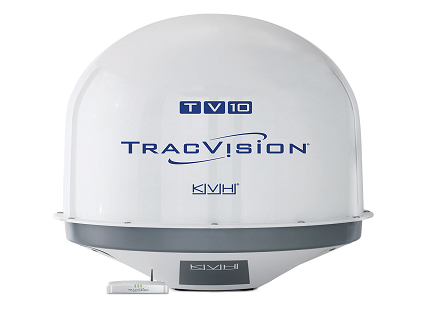
KVH Industries, introduces its TracVision TV10, the newest 1-meter global marine satellite TV antenna that deliver expanded Ku-band HDTV coverage and ultra-high efficiency. It is designed to provide boat owners, charter yacht guests, and commercial vessel crews with access to live news, local channels, and TV and movie programming from leading satellite TV providers worldwide.

TracVision TV10 – the world’s lightest 1-meter Ku-band marine satellite TV antenna, weighing up to 10% less than leading competitive products – features KVH’s advanced inertial-based stabilized search functionality for fast satellite acquisition and proprietary RingFireTM technology for strong signals, wide geographic coverage, and clear reception. For easy upgrades, the TracVision TV10 features an antenna mounting pattern that matches competing 1-meter systems; system configurations support multiple receivers with simple onboard integration. The innovative belowdecks TV-Hub and TracVision app are designed to enable straightforward setup and operation.

Whether it is a guest on a superyacht wanting to watch a favorite show or a seafarer hungry for news about world events, the TracVision TV10 provides crystal clear reception and reliable coverage offshore and in remote locations,” says Jim George, KVH’s senior director of global leisure sales.

The TracVision TV10 supports HD and SD programming from circular and linear Ku-band services around the globe. Boaters and crews can choose from an array of popular satellite TV programming services including DIRECTV®, DISH Network®, Bell TV, SKY, Canal+, TrueVisions, Orbit Showtime Network (OSN), DIRECTV Latin America, and more.

A recognized leader in marine satellite antenna technology, KVH’s TracVision line of products has won Product of Excellence awards from the National Marine Electronics Association (NMEA) for 22 consecutive years. KVH TracVision products include worldwide technical support delivered by more than 4,900 factory trained technicians in KVH’s global Certified Support Network (CSN) and KVH’s expert field service and technical support teams.

For more information visit https://www.kvh.com/

A high-end signal & spectrum analyzer supporting 8.3 GHz internal analysis bandwidth

Signal and Spectrum analyzer

Rohde & Schwarz announces the launch of the new R&S FSW-B8001 option, a high-end signal and spectrum analyzer that supports an industry-leading 8.3 GHz internal analysis bandwidth. The instrument covers an input frequency range of up to 90 GHz and offers unequaled dynamic range and sensitivity, precision and EVM performance.

Equipped with the extended analysis bandwidth option and dedicated measurement applications, the signal and spectrum analyzer meets current and future test and measurement requirements for ultra wideband signal analysis across different industries. Applications for the R&S FSW include pulse measurements of A&D radar systems, satellite payload testing and amplifier pre-distortion tests. The instrument also covers chirp analysis for automotive radar and research on the next generation of wireless communication.

The trend toward higher signal bandwidth continues in virtually all high frequency applications. In radar technology, for example, wider bandwidths lead to better range resolution for object detection. When developing and verifying both radar systems and radar jammer systems, wideband acquisition makes it possible to analyze frequency hops in detail while examining different radar systems operating at different frequencies.

Increased bandwidths are the norm also in wireless communications technology, with every new technology generation requiring ever higher data throughput. For instance, the IEEE 802.11ay standard for Wi-Fi supports channel bonding, which leads to signals with bandwidths greater than 8 GHz. Suitable wideband T&M equipment is also needed for upcoming gigabit communications sub-THz bands, such as D-Band and G-Band, which are often named as potential frequency ranges for a future 6G wireless communication standard.

Future satellite systems will also operate with higher frequencies and wider bandwidths as bandwidths are expected to increase to 3 GHz or 5 GHz at frequencies up to 90 GHz, e.g. for high throughput satellites designed to support terabit connectivity.

For these ultra-wideband systems, signal analysis has so far generally been possible via a workaround only. Former approaches for ultra-wideband signal analysis made use of signal and spectrum analyzers as wideband downconverters. The downconverted signals were fed into an oscilloscope, digitized and fed back to the analyzer. The new solution with the R&S FSW offers far higher signal quality and sensitivity in a user-friendly, one-box solution – combined with fully featured and signal analysis capabilities that also offer spectrum analysis functionalities.

The new R&S FSW-B8001 internal analysis bandwidth option is now available from Rohde & Schwarz. For more details, visit https://www.rohde-schwarz.com/product/fsw.

Hexagon’s Latest Positioning & Sensing kits Demonstrated by Pioneering R&D Tractor

Positioning and Sensing kits

Hexagon’s Autonomy and Positioning division has launched its first autonomy Positioning and Sensing Kits for the agriculture market and demonstrated by its new autonomous research and development tractor. Through collaboration between NovAtel and AutonomouStuff, both leading brands of Hexagon, the autonomous positioning and sensing kits were developed as part of Hexagon’s Smart Autonomous Mobility solutions portfolio launched at CES in early 2020. With decades of expertise in GNSS positioning, autonomy and safety-critical applications, NovAtel and AutonomouStuff created these solutions with agriculture machinery OEMs and robotic machinery manufacturers in mind.

As a demonstrator vehicle for Smart Autonomous Mobility, the autonomous tractor features object detection and classification, simultaneous relative localization and mapping, absolute positioning through GNSS technology, and localization sensor fusing. Built to illustrate the viability of new positioning and sensing kits, the tractor incorporates safety-critical learnings with situational and environmental awareness, and manual remote control when needed. This platform validates how these solutions and capabilities accelerate autonomous development.

The positioning and sensing kits are optimized for autonomous agriculture applications, including products like the SMART7 antenna and autonomous robotic capabilities through the NovAtel OEM7 driver powered by the Robot Operating System (ROS™). The kits also feature TerraStar GNSS Correction Services, ALIGN heading and relative positioning firmware, and SPAN GNSS+INS technology. Though designed for agriculture, the kits integrate seamlessly into other off-road autonomy applications.

“These positioning and sensing kits provide developers with technology bringing assured positioning to autonomy in agriculture,” explained Michael Martinez, agriculture segment manager at Hexagon | NovAtel. “Robotic-machinery manufacturers or those experienced in autonomy may be unfamiliar with the unique challenges facing agriculture applications. Conversely, those experienced with agriculture may not have the expertise to integrate positioning and sensing products within autonomous solutions. We can help in both cases through these positioning and sensor kits, as demonstrated by our autonomous tractor.”

“We’re excited to use this tractor as a platform to validate the human identification, obstacle detection and enhanced environmental awareness that our sensing kits add to our assured positioning solutions in agriculture,” said John Buszek, VP of products and services at Hexagon | AutonomouStuff. “The sensing and positioning technologies we’ve integrated on this demonstration platform showcase the Smart Autonomous Mobility portfolio, which enables and accelerates the development of autonomy in agriculture applications from prototyping to production.”

For more than 30 years, NovAtel has delivered industry leading GNSS positioning solutions as a trusted provider for the world’s top precision agriculture companies. Combined with AutonomouStuff’s decade of expertise in autonomy and sensor fusion, they significantly reduce the barrier of entry into autonomy to accelerate the time to market for autonomous solutions in agriculture, construction, mining and other off-road applications.

Learn more about their agriculture autonomy capabilities by taking a virtual tractor tour via their 3D interactive app at https://bit.ly/3hSao9M or online at http://www.novatel.com/ag-autonomy.

Hexagon|VERIPOS’s SPAN GNSS+INS technology for hydrographic survey applications

GNSS hydrographic survey
Hexagon | VERIPOS launches SPAN GNSS+INS technology for hydrographic survey applications

Hexagon | VERIPOS introduces its SPAN GNSS+INS technology for offshore oil and gas marine market. For over 15 years, NovAtel and its SPAN technology have accelerated development in GNSS positioning, sensor fusion and inertial navigation systems. Now, VERIPOS brings this proven technology to the marine market to optimize your positioning solution with GNSS and inertial measurement units (IMUs) to provide heading, attitude and heave measurements on the open water.

Through deep coupling, SPAN technology fuses measurements from the GNSS receiver and the IMU together to calculate a robust and reliable position, heading, velocity, attitude and heave. This process delivers a holistic and precise 3D solution, powering hydrographic survey applications through extended GNSS outages. The solution is scalable with multiple different IMUs, the VERIPOS LD900 receiver, and Quantum visualization software.

The LD900 with dual-antenna functionality is able to unlock the SPAN GNSS+INS integration technology that has a long and successful track record,” explained Hexagon | VERIPOS Marine Segment Portfolio Manager Dr. David Russell. “The latest evolution of SPAN technology for marine has improved performance through deep coupling to provide exceptional positioning, velocity, attitude and heave measurements in highly demanding offshore hydrographic survey applications. The simple upgrade path to INS capability with the LD900 makes it a great choice for users in the market.”

To learn more about SPAN technology for offshore hydrographic survey applications, visit https://www.veripos.com/products/span-gnss-ins-technology. Download the media kit at     
https://bit.ly/2FdsyEy.

CHC Navigation’s i73 GNSS and iBase GNSS receivers

i73GNSS & iBase GNSS receivers

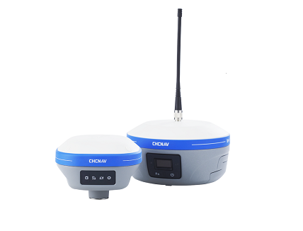
CHC Navigation (CHCNAV) announced its pocket-sized i73 GNSS and iBase GNSS receiver which is powered by IMU-RTK technology. This combination of receivers is the most productive and affordable solution for measuring and staking out points in any surveying, mapping, or construction application.

“Surveyors and construction professionals are forced to carry heavy and cumbersome GNSS receivers in most situations, resulting in unnecessary fatigue and lower productivity,” said Hans Huang, product manager of CHC Navigation’s Survey and Engineering Division. “Taking this into account, we have developed our pocket-sized i73 GNSS, the lightest GNSS rover powered by the latest IMU-RTK technology, and much more. Our iBase GNSS station follows the same concept of an all-in-one solution, making the need for external radio modems and other bulky accessories obsolete”.

The i73 Pocket IMU-RTK GNSS | A new scale to GNSS

Best-in-class technology but at an affordable price. The i73 GNSS offers superior GNSS signal tracking enabling surveys beyond the usual constraints. It features full 624-channel GNSS technology and connects seamlessly to RTK GNSS networks as well as to UHF GNSS station over its embedded UHF modem.

Automatic pole-tilt compensation. The i73 GNSS internal interference-free inertial module (IMU) allows automatic pole tilt compensation of up to 45 degrees. Projects are completed 30% faster and with increased efficiency and safety when measuring hard-to-reach points.

Weighs less, works longer. The i73 takes GNSS to a new scale. With only 730 g and 15 hours operating time, the i73 GNSS is one of the lightest and most rugged RTK GNSS receivers on the market. Easy to carry and use, the i73 will not tire you out.

The iBASE GNSS | Redefining the concept of GNSS base station

The GNSS iBase is a fully integrated GNSS base station, specifically designed to meet 95% of surveyors’ needs when working in UHF GNSS base and rover mode. The performance of the iBase UHF base station compared to a conventional external UHF radio modem is virtually identical. But its unique design eliminates the need for a heavy external battery, bulky cables, an external radio, and a radio antenna. Its 5-watt radio module provides operational GNSS RTK coverage up to 8 km.

Digi-Key Electronics stocks Septentrio’s mosiac-X5, a high-end GNSS receiver module

Digi-Key Electronics, a global electronic components distributor, announced today that it has partnered with Septentrio, a leader in high-precision GNSS positioning solutions. Digi-Key now offers mosaic-X5 globally for customers who need secure and reliable high-accuracy positioning in a compact and low-power form factor.

Septentrio’s mosaic-X5 features complete multi-frequency multi-constellation technology and tracks every existing and future signal from all Global Navigation Satellite System (GNSS) constellations. Such signal diversity coupled with advanced anti-jamming technology allows mosaic-X5 to deliver centimeter-level positioning with maximum availability even in challenging industrial environments. This makes mosaic-X5 an ideal positioning solution for applications such as robotics, automation, telematics and many more.

“Our mosaic-X5 is an advanced GNSS receiver module without performance compromises. With its small form factor and low-power design, mosaic-X5 brings high-performance positioning to volume applications,” said Francois Freulon, head of product management for Septentrio. “Having Digi-Key as a distributor enables us to scale and reach out to find new markets and applications where secure high accuracy positioning is required.”

“Digi-Key is excited about the new partnership with Septentrio,” said David Stein, vice president of global supplier management for Digi-Key. “Demand for high-accuracy GNSS receivers with secure and robust positioning is growing strongly, as they continue to be implemented into new applications and devices. Digi-Key offers customers an easy path to order, develop, and deploy with the latest technologies available, including Septentrio’s robust and precise GNSS devices, which have the latest anti-jamming and anti-spoofing technology.”

For more information about Septentrio and to order the mosaic development kit or the mosaic-X5 module, please visit the Digi-Key website.

u-blox Bluetooth 5 module in wearable devices for tracking Covid-19

wearable devices for tracking

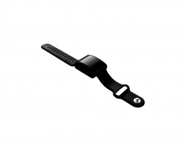
To combat the current global Covid-19 pandemic, u-blox has revealed its power efficient Bluetooth 5 module for wearable devices. Available as either a pendant or a wristband, the TDS‑50 developed by Electronic Precepts present highly-effective tracing and tracking solution that will store the data directly on the device and then sent it to the web server periodically. To maintain the social distancing the device features vibrational and visual alerts if another TDS-50 wearer comes within a 2 meter distance for over 45 seconds.

The TDS-50 units needed a compact form factor to make them comfortable for the user to wear. It has the ability to deliver passive scanning (for social distancing purposes) over a period of up to 240 hours and support ultra-low power operation.

The u‑blox ANNA-B112, a Stand-alone Bluetooth 5 low energy proved itself to have all the attributes needed. With dimensions of just 6.5mm x 6.5mm x 1.2mm, this space-saving, highly-integrated and pre-approved system-in-package (SiP) is optimized for situations where a swift turnaround is mandated. It is based on Nordic’s nRF52832 chip-level Bluetooth technology, with a 64MHz Arm® Cortex®-M4 processing resource plus 512kB of embedded flash memory. Supporting 1.4Mbit/s data rates, it is highly suited to wearables applications and does not impact heavily on battery reserves.

“u‑blox were able to satisfy all our expectations with the ANNA-B112 module, allowing us to bring our track and trace device to market within a very short timeframe, while also addressing the stringent space and power constraints that had been set,” states Jeff Singer, CEO of Electronic Precepts. “Over ten thousand TDS-50 units have already been shipped and demand is ramping up every day. We see huge potential for it in schools, businesses and theme parks, as well as within airport environments.”

“This collaboration with Electronic Precepts gives us a valuable opportunity to highlight all of the key elements that make u‑blox technology so appealing to numerous industry sectors,” adds Carl Bellanca, Head of Sales for u‑blox Americas. “It underlines our ability to provide cutting-edge wireless solutions that have all the necessary processing and data storage capabilities, while also taking up minimal space and drawing only a relatively small amount of power.”

Latest u-blox GNSS technology platforms offer out-of-the-box support for recently completed BeiDou-3 navigation satellite system modernizations

u-blox a global provider of leading positioning and wireless communication technologies and services, announced today that its current GNSS platforms, from u-blox M8 and beyond, support the recently completed BeiDou navigation satellite system modernizations, improving the availability of GNSS positioning services. The opening ceremony of the BeiDou-3 global navigation satellite system (GNSS) was held in Beijing on July 31, officially celebrating the expansion of coverage offered by the critical Chinese space infrastructure to a global user base.

As a global supplier of industry-leading GNSS positioning and wireless communication technologies, u-blox has been driving technological innovation and deeply involved in the Chinese market for many years. Tests conducted across China and Europe have shown that including the BeiDou system can improve the positioning accuracy of GNSS receivers when multiple navigation satellite systems are tracked concurrently. In particular when signals are partially obstructed, positioning accuracy can be significantly improved by incorporating the BeiDou system.

GNSS: a winning ingredient in emerging applications
Data shows that in 2019, the overall output value of the Chinese satellite navigation and location service industry reached nearly 345 billion yuan, an increase of 14.4% over 2018, with the output value expected to exceed 400 billion yuan in 2020. The BeiDou global navigation satellite system provides a whole suite of additional services, including satellite and ground-based augmentation services, precise single-point positioning, precise timing, and global short message services, laying a solid foundation for BeiDou’s ubiquitous navigation and tracking applications.

Applications of GNSS technology continue to diversify, leveraging the all-weather, all-time, tracking, navigation, and timing services it offers. GNSS technology is penetrating deeper into traditional industrial verticals, such as agriculture, forestry, animal husbandry and fishery, power and energy, as well as in railway and air transportation, including their infrastructure construction and management.

At the same time, GNSS technology has become an indispensable and “smart” winning factor in emerging application fields such as the Internet of Things and the Internet of Vehicles, as well as in innovative applications such as autonomous driving, automatic parking, and automatic logistics, and is now commonplace in many industrial and consumer use cases.

“u-blox has been closely following the modernization of the BeiDou navigation system and is ready to work with partners in various industries to promote the expansion of industry applications, expand emerging markets, and jointly create a green industry ecosystem,” says Hamilton Chen, China Country Manager at u-blox.

World’s First Public Test of IoT 5G Satellite Communications with Inmarsat

Test of 5G Satellite IoT Data Connection

MediaTek is pushing the boundaries of advanced IoT 5G Satellite Communications with a successful field trial that transfers data through Inmarsat’s Alphasat L-band satellite, in Geostationary Orbit (GEO) 35,000 kilometers above the equator.

The results of MediaTek and Inmarsat’s IoT field test will be contributed to the 3rd Generation Partnership Project (3GPP)’s Rel-17 standardization work on Non-Terrestrial Network (NTN), which is part of its overarching initiative to establish 5G standards toward new use cases and services.

The new 5G satellite NB-IoT technology established a bi-directional link from MediaTek’s satellite-enabled standard NB-IoT device to a commercial GEO satellite, breaking new ground for a truly global IoT coverage. The successful test builds the foundation for hybrid satellite and cellular networks to enable new ubiquitous 5G IoT services at a global scale.

“MediaTek’s collaboration with Inmarsat will accelerate industry efforts to converge cellular and satellite networks in the 5G era. MediaTek is a leading connectivity provider and contributor to 3GPP standards, and our ongoing work with Inmarsat GEO satellites will help drive 5G innovation across verticals like IoT,” said Dr. Ho-Chi Hwang, MediaTek General Manager of Communication System Design.

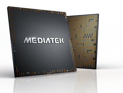
MediaTek is the world’s 4th largest fabless semiconductor company and Inmarsat is the world leader in global, mobile satellite communications. The two companies ran the test with a base station located at the Fucino Space Center in Italy and developed by Taiwan’s Institute for Information Industry (III). The test device, built with MediaTek’s satellite-enabled NB-IoT chipset, was located in Northern Italy. The prototype system successfully established a communication channel and data transfer with the GEO satellite ‘Alphasat’.

The successful test could provide proof as to the feasibility of new global standards and open market potential of using a single device for connecting both satellite and cellular networks.

“Testing MediaTek’s standard NB-IoT chip over Inmarsat’s established GEO satellite network has proven technology from mobile networks works effectively over GEO satellites with little modification and will provide a very cost effective path to ubiquitous and hybrid global IoT coverage,” said Jonathan Beavon, Senior Director, Inmarsat Product Group.

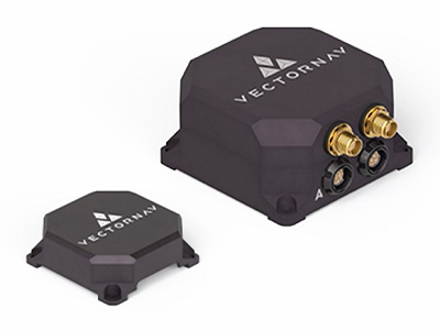
VECTORNAV INERTIAL NAVIGATION SYSTEMS EARN MIL-STD AND DO-160 CERTIFICATIONS

VectorNav Technologies, a leading provider of inertial navigation systems, has completed a series of MIL-STD and DO-160 qualification tests for its Tactical Series line of IMU and GNSS/INS products. The testing proves the robustness of the Tactical Series to a range of temperature, shock, vibration and other environments, as well as conformance to numerous electrical interface and EMI standards. Together with the unmatched SWaP-C to performance characteristics of the Tactical Series, the testing demonstrates yet another advantage of the Tactical Series for defense and aerospace applications.

“There is high demand for dependable, tactical-grade navigation solutions that perform in challenging environmental and operating conditions,” stated VectorNav Director of Sales and Marketing, Jakub Maslikowski. “As the smallest, most costeffective INS with this level of performance and robustness, the Tactical Series is the superior choice for systems integrators seeking these solutions.”

Testing for the MIL-STD and DO-160 standards was performed by independent, certified testing companies in Plano, TX and Huntsville, AL.

VectorNav Technologies is exhibiting at the Association of the Unites States Army’s (AUSA) Annual Meeting in Washington, D.C., October 14-16, at booth #4029. For additional information on the completed and ongoing MILSTD and DO-160 testing, or to schedule a meeting time during AUSA, contact VectorNav at: email: sales@vectornav.com; tel: +1-512-772-3615; web: www.vectornav.com.