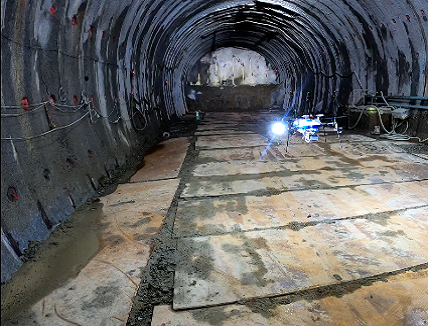
Aerosense conducted Tunnel Inspection with an Automatic Flight Drone in an environment where radio waves such as GPS do not enter, demonstrate automation of indoor inspection, which was difficult until now
This time, Aerosense Co., Ltd. is developing a non-GNSS that can automatically fly in an environment where radio waves such as GPS do not enter. Aerobo Inspection, an inspection drone, is collaborating with Tobishima Construction Co., Ltd. to conduct a tunnel under construction from August 29 to 30, 2020. At the construction site, we performed automatic flight and photography in the tunnel being excavated, and generated ortho data and 3D point group data that can be effectively used for tunnel inspection. (Global Navigation Satellite System / Global Positioning Satellite System, a general term for satellite positioning systems such as GPS)
Tunnel construction is a dangerous site that can cause serious accidents when it comes into contact with people using large heavy machinery. Drones are expected to be used because people need to be very careful when checking the excavation status. Since a normal automatic flight drone cannot estimate its own position in a tunnel where GNSS radio waves do not reach, advanced maneuvering technology is required, but this flight was able to automatically fly within a fixed range. In the future, it is expected that drones will automatically fly to dangerous places to check the situation safely and easily on behalf of people.
[ACHIEVES AUTOMATIC INDOOR FLIGHT, WHICH WAS DIFFICULT WITH CONVENTIONAL DRONES]
In the field under non-GNSS environment with conventional drones, it is not possible to perform automatic flight because it is difficult to estimate the self-position and orientation of the drone, and it requires advanced maneuvering skills of a skilled drone operator to collect data. It was a personal work. The inspection drone and aerobo inspection developed this time currently have the functions and performance that enable automatic flight even in a non-GNSS environment.
Instead of GNSS, the aircraft recognizes the self-position and orientation of the aircraft using Visual SLAM technology that simultaneously estimates the three-dimensional information of the environment and the position and orientation of the aircraft from the images taken by the camera. In addition, it is equipped with high-brightness lighting for indoor inspection applications, and it is possible to create ortho-images and 3D point clouds to be inspected from photographs with sufficient brightness.
[SIGNIFICANTLY STREAMLINED INSPECTION RESULT DATA GENERATION AND COST REDUCTION]
In the past, the process of taking aerial photographs in a non-GNSS environment was difficult, but even after aerial photography, it was necessary to occupy a dedicated computer and generate ortho images over many hours. Therefore, by using our cloud service, Aerobocloud ( https://aerosense.co.jp/aerobocloud ), which has been inspected this time, it is easier to operate than existing software and less than half the processing. You can perform data generation in time. All you need to do to generate the data is upload the photo and press the calculation start button, and the ortho image and 3D point cloud will be generated automatically. Aerobo Cloud can reduce man-hours by high-speed processing and simple operation, and functions are improved and added every day at no additional cost, and total cost reduction from introduction cost to running cost can be realized.
[SUPPORTS CUSTOMIZATION REQUIRED FOR VARIOUS INSPECTIONS]
The functions required for inspection are diverse depending on each inspection target and environment, but since Aerosense develops hardware, control software, and cloud services in-house, it corresponds to each inspection target. Customization is possible. Corresponding to the inspection required by the customer, such as the sensor on the drone side that acquires data, the payload such as a camera, the lighting system, etc., and the deep learning technology and various processing in the cloud system on the data processing side. In the future, we will continue to contribute to the challenges of the world by responding to the needs of inspections, including the construction field, which has received many requests.
FEATURES OF AEROSENSE’S NON-GNSS ENVIRONMENTALLY FRIENDLY INSPECTION DRONE, AEROBO INSPECTION
- Automatic indoor flight is possible without GNSS radio waves
- Supports magnetized environments by flying without relying on geomagnetic sensors
- Easy-to-operate operation terminal eliminates the need for advanced maneuvering skills
- Equipped with a gimbal camera equipped with an APS-C sensor
- High-brightness lighting can be installed, allowing flight and data acquisition even in the dark
- Payload customizable
- Communication expansion such as LTE is possible
- Equipped with collision avoidance function
- Significantly streamline data generation and reduce costs in the cloud


