


Q1: Please introduce your company’s ICT-related civil engineering works so far.
In July 2015, we purchased the first drone (manufactured by DJI), applied for the permission to fly, and started aerial photography at the construction site in December of the same year. In fiscal 2016, we established the i-Construction Promotion Team to tackle ICT construction in earnest. We visited construction contractors working on ICT construction in other prefectures and started work by collecting information necessary for ICT utilization, such as drones and analysis software. In May of the same year, we started trying 3D land surveys by drones, and the first ICT construction machine “Machine Guidance Excavator” was introduced in the field to verify the effectiveness of the use. In September 2016, five months after the start of the trial, we gradually established our own manual with the cooperation of ICT construction equipment leasing companies and software manufacturers, and we have implemented the first full-scale ICT utilization work (riverbed excavation) under the “contractor choice type” for the first time in government-backed construction. As of April 2020, 12 full-scale ICT utilized works, including current construction works, have been implemented.
Q2: How did you know Aerosense, and why did you choose our products?
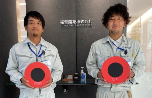
From left, Mr. Tamura and Mr. Takemura)
We made extensive use of aerial photography but struggled with the installation of Ground Control Points and the amount of time it takes to survey reference points for GCPs. In the midst of this, we heard about AEROBO markers from survey equipment distributors and immediately asked for a presentation at our company. At that time, while some in the company were worried about their cost effectiveness and others felt that it would be possible to reduce the working time by introducing AEROBO markers, we decided to purchase them in order to further enhance the use of ICT.
Q3: How have you made use of Aerosense products?
The primary use of AEROBO markers is for 3D land surveying by drones. In addition, we have also introduced them for reference point surveys for site piles.
Q4: How did you find it when you tried AEROB markers? (Good points, improvement requests, etc.)
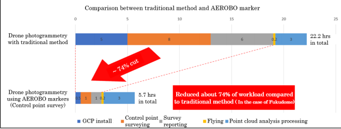
The anxiety I felt before the purchase was completely wiped out upon using it. We continue to make good use of AEROBO markers and the AEROBO cloud – mainly for reference point survey calculations. AEROBO markers can be installed easily and positioning information can be obtained simply by placing them for about an hour. The rest is done automatically by AEROBO cloud. The result is survey grade data and the reports can be used in public works without any problems. The time and effort involved in placing GCPs is a significant bottleneck in aerial photogrammetry which has been completely eliminated by the use of AEROBO markers. Compared to the use of conventional GCPs, it is possible to reduce workload by approximately 74%, and the reduction rate of workload is expected to improve almost proportionally to the size of the survey area. In addition, by utilizing AEROBO markers, it has been possible to undertake aerial photogrammetry work at very short notice, allowing us to respond quickly to our clients’ requests.
Q5: What are your expectations for Aerosense and what are your ICT initiatives in the future?
AEROBO cloud provides a great deal of functionality, and it is a must-have in our company in proceeding with ICT utilization work. We expect further improvement of positioning and calculation speed.
Finally, a message from Aerosense to your company;
Thank you very much for using AEROBO marker & AEROBO cloud and for your detailed report. I remain very impressed with your willingness to make most of the product in your own company at our first introduction and explanation of the product by our sales partner in Kochi Prefecture. In terms of work man-hours, the reference point survey-related processing was more efficient than we expected. It is a pleasure to us that your company has been able to realize the reported levels of efficiency in the field. We will continue to improve and propose services so that we can contribute to further efficiency of ICT construction sites. Thank you for your continued support.


