


TOPODRONE to release a new lightweight 360° LiDAR model range with advanced features and capabilities: LiDAR 100 & 100+ with a 100 m working flight altitude and LiDAR 200+ with a 200 m working flight altitude. All of them can be used as a single payload for different carriers and installed on a drone, car and backpack. The product launch is planned at Geo Business in London on May 17-18.
TOPODRONE LiDAR 200+ has successfully passed field tests and has been implemented in a test mode by two European customers. BDS Topografie conducted a surveying project in Romania to study a dam and mountain river with a very difficult terrain structure.
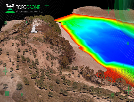
Atyges and Gonzalo Malvarez from the Coastal Environments research group of the Universidad Pablo de Olavide de Sevilla experimented with the combination of bathymetry, LiDAR and photogrammetry approaches to survey a reservoir in Spain.
‘LIDAR 200+ is a brand new R&D of the TOPODRONE team. The field tests confirm a new level of accuracy and precision with an improved high performance GNSS based inertial navigation system. The compact design with a payload weight of 800 grams increases flight time and efficiency while the maximum flight altitude of 200 meters helps to perform the survey in difficult to access mountain and forest areas. The hardware is compatible with TOPODRONE Post Processing software‘, Maxim Baklykov, TOPODRONE CEO, explains.


