Friday, October 24, 2025
Home Blog Page 244

Smart Agriculture through GPS Technology

GPS Technology in Agriculture

GPS Technology in Agriculture is revolutionising the farming practices while providing many benefits & various opportunities to farmers

Global Positioning System (GPS) has always ranked high in the field of navigation system and has provided numerous applications to different industries. One such is the agriculture industry which is revolutionising with the use of digital technologies in farming such as drones, remote monitoring, sensors and GPS technology in farming practices.

GPS system provides many benefits and various opportunities to farmers for effective farming practices, crop maintenance and production of good quality of crops by monitoring and eliminating pathogen affected areas through early treatment.

GPS help farmers to continue their work accurately during low visibility field conditions such as night and dirt. It helps in navigating the particular location in the field, collecting the samples of soil, identifying the accurate areas of the field or any tree affected by pathogen to prevent the damage.

The technology has not only gained importance in the field of Precision farming and Site-specific farming but has also helped farmers to monitor the crop health at different stages of its development process in different weather conditions.  Here are some of the uses of GPS technology in agriculture –

  • Creating yield maps: GPS data is used to create the yield map which helps in comparing the yield distribution every year within a field and thus help farmers to examine the areas that are not yielding any crop or those which require more irrigation. The data also analyse the content of moisture in a field.
  • Sampling of soil: GPS along with mapping software helps in organizing the collected soil samples from fields. This data is used to determine the properties and conditions of soil which gives the information that whether a soil is fit for a particular type of crop or not. It also help in the optimal use of fertilizer and pesticides and control pollution.
  • Tractor guidance: The RTK GPS for tractor acts as a manual guidance system for it. Ploughing a field with a recording GPS system enable in programming a tractor to follow the same route for cultivation, harvesting and spacing required between the crops.
  • Weed Location: Weed hinders the growth of a plant. The GPS system help in the growth of a crop by determining weed location through the technique of linear sampling.
  • Developing tools: GPS equipped tools with programming improve farming activities and help agribusiness to become more efficient and productive.
  • Determining harvesting: GPS has a major role in determining harvesting as it helps in estimating the size of area to be harvested and how it will take place.
  • Accurate planting: With the help of GPS, planting can be done accurately as it tells the depth and spacing required for a seed to be planted.
  • Tracking Livestock: GPS transmitters attached to animals collar help in tracking their location on large farms.
  • Cropduster targeting:  GPS records the location of areas affected by pathogen and insects problems. The data help Cropduster pilots to selectively target the affected areas instead of treating an entire field as a result saves time and control exposure of chemicals.

GNSS Firewall Software Update to Strengthen GNSS Protection

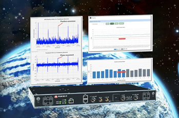
Critical infrastructure systems including power utilities, financial services, mobile networks, and transportation rely on Global Positioning System (GPS)-delivered timing to ensure ongoing operations. Microchip Technology announced the release of a major software update for its BlueSky GNSS Firewall product, providing a higher level of resiliency against GPS vulnerabilities for systems dependent on GPS signal reception. 

Microchip’s BlueSky GNSS Firewall Software Release 2.0 performs real-time analysis to detect jamming and spoofing for protecting the reception of the GPS signal and hardening response and recovery to avoid signal disruption. BlueSky GNSS Firewall Software Release 2.0 includes charting and advanced threshold settings of Global Navigation Satellite System (GNSS) observables such as satellites-in-view, carrier-to-noise, position dispersion, phase time deviation, and radio frequency (RF) power level to simplify system turn-up and deployment.

BlueSky GNSS Firewall Software Release 2.0 includes improvements developed by Microchip as a result of participation in an industry live-sky testing event hosted by the U.S. Department of Homeland Security (DHS) Science and Technology Directorate and open to all providers. Microchip’s participation in the DHS-hosted GPS Testing for Critical Infrastructure (GET-CI) events, with scenarios including spoofed signals, has helped the company to identify new solutions to prevent signal disruptions. As a result of 2019 live-sky testing and other input, Microchip developed the Blue Sky GNSS Firewall Software Release 2.0 to address operators’ evolving requirements.

As a leader in frequency and time systems, Microchip continuously innovates GPS signal reception security technologies for commercial and military operators similar to how network firewalls protect against virus threats. Updates are essential to defend against rapidly-evolving GNSS disruptions and enable critical infrastructure operators to avoid interruptions of service.

Microchip’s BlueSky GNSS Firewall Software Release 2.0 is provided as part of a subscription service and is installed on the BlueSky GNSS Firewall device. When connected to Microchip’s TimePictra management software, critical infrastructure operators also can monitor and analyze GNSS signals in cities, across geographic regions, throughout a country and even globally.

Other complementary devices and software in Microchip’s suite of GPS systems and services include the TimeProviderÒ 4100 Precise Timing Grandmaster with Gateway Clock, SyncServer 600/650 timing, and frequency instrument, miniature atomic clock (MAC), Time Cesium and 5071A cesium primary frequency standard.

U.S. Military Contract for Advanced GPS Simulation Suite

In a recently awarded contract, the U.S. military selected Orolia Defense and Security to supply multiple BroadSim advanced GPS simulator systems, a contract valued at $1.7 million (USD), in an effort to upgrade testing facilities and field test assets.
 
These new simulator systems will enable better testing of widely deployed military GPS receivers, which are integrated into air and ground-based Positioning, Navigation and Timing (PNT) systems. BroadSim will be leveraged with Orolia’s PANACEA test suite, currently utilized by the U.S. military to conduct automated testing and analysis for PNT system performance, vulnerabilities, and more.
 
BroadSim will bring versatility to the testing process by supporting diverse test methods and environments such as a laboratory setting, or an Over-The-Air (OTA) field test event. BroadSim was selected based on its flexibility to support the ever-changing military tasks at hand. It can be easily configured to support laboratory testing one day, and field testing the next with its four independent RF outputs, removable drives, and software-defined architecture.
 
“Equipping our actively deployed warfighters with state-of-the-art technology is of utmost importance and can mean the difference between mission success and failure. To help achieve that goal, Orolia’s GPS testing and simulation solutions ensure that these systems are battlefield ready,” said Tyler Hohman, Orolia Defense and Security’s Director of Products.
 
Now more than ever, strong relationships between government and industry are vital to drive innovation and maximize the impact of available resources. The U.S. military and other federal agencies such as DHS host several test events per year where industry partners are invited to participate, such as  GPS Testing for Critical Infrastructure (GET-CI). Orolia will host a webinar on this topic on Thursday, July 16 at 2:00 PM EDT, titled “PNT Vulnerability Testing for Critical Infrastructure – Lessons Learned from Defense.”
 
The federal government considers PNT to be a critical aspect of mission success, as outlined in this recent C4ISRNET Whitepaper “Protecting the U.S. Military PNT Advantage from GPS Jamming and Spoofing” and defined in the PNT Executive Order. For the 2021 federal fiscal year, the U.S. Army alone budgeted over $275 million towards Assured PNT Research, Development, Test & Evaluation (RDT&E), as published in the 2021 Defense Budget.
 
For more information about Orolia Defense & Security, visit www.OroliaDS.com

Navigation with Indian Constellation (NavIC)

What is NAVIC or Indian Regional Navigation Satellite System (IRNSS)

Indian Regional Navigation Satellite System (IRNSS) or NavIc is an independent regional satellite navigation system developed by ISRO. This Indian made navigation system is fully operated by India which is designed to provide the accurate real time positioning information and services for the civilians and Indian military purposes by focusing on India and its adjoining regions only, with plans for further extensions of the system.

Why is it?

To replace or to avoid its dependency on the US Air Force owned satellite-based radio navigation system GPS, India designed its own navigation system. The purpose behind NavIc is to have the complete independent authority of navigation system for the military purposes of the country without being dependent upon encrypted system data sources of any other country.

NavIc has Geostationary satellites whose positions are fixed with respect to certain locations which is India in this case and thus called a regional navigation system. It covers the positioning information with great accuracy due to its dual band frequency system. It provide better accuracy more than 20 meters within its primary range service area in addition to extension upto 1500 km outside the borders of the country with higher resolution capability along with wider extended service area.

Type of services:

  • Standard positioning system (SPS) which is public based unencrypted system available to civilians having a range of 10 m to 5m. 
  • Restrictive Service (RS) which is encrypted system having a signal of 0.1 metre meant only for authorized users such as armed forces, ISRO and DRDO.

How it works:

NavIc is GEO and GSO based navigation system which has 7 satellites positioned in the high orbit of earth at an altitude of 35,000 km from its surface. India being close to the equator has an advantage of using the Geostationary orbit that allows the use of less satellites for the working purpose.

NavIc uses 3 satellites in Geostationary orbit (GEO) stationed at 32, 83 and 131 degrees respectively and remaining 4 satellites at Geosynchronous orbit (GSO) at 55 and 111 degrees for better and more coverage.

It has two band antenna S band and L band having a difference of 1 gigahertz between them which make delay analysis possible between the bands and thus provide more accuracy than GPS which uses a single band frequency making the signal slow and complex to calculate. This dual frequency bands help to keep the data or signal unaffected and correct due to any fluctuations in the weather.

 A small data link is also added in the system so that by broadcasting a data can be send immediately in case of any upcoming marine disaster or any mishap in the ocean or nearby sea coast to the coastguard receivers for issuing high alert and evacuation of the region if required. It could be beneficial for the commercial purposes of shipment, and also for Indian Navy for tackling the pirates attack.

Future of NavIC:

The future plan is to make NavIC a Global Indian Navigational System (GINS) which will use 24 satellites stationed at 24,000 km (MEO) orbit so as to make it more efficient and useable in the entire earth globally to help the armed forces of the country.

The upcoming smartphones in India will have the inbuilt technology of the NavIc system that will be helpful for the mariners and fishermen. A further enhancement is going on in the system to make it more suitable and efficient to provide the users of the country with precise time and location mapping in remote with visual and voice navigation.

Spirent Collaborates with Rakuten Mobile on Core Network Testing

spirent

Spirent Communications plc a leading provider of test, assurance, and analytics solutions for next-generation devices and networks, today announced its extensive work with Rakuten Mobile, Inc. in support of the operator’s current LTE services, planned 5G Non-Standalone (NSA) and Standalone (SA) rollout in Japan for its world-first fully virtualized cloud-native mobile network. 

Rakuten Mobile required groundbreaking testing capabilities to assure the performance of new services and selected Spirent Landslide for core network testing. With LTE services now live and deployment of its 5G NSA network planned for later in the year, Spirent will work with Rakuten Mobile to ensure a solid customer experience. 

“We are excited to collaborate with Spirent for core network testing,” said Tareq Amin, representative director, executive vice president and CTO of Rakuten Mobile. “Given their extensive in-region and global MNO/MVNO experience, advanced methodologies for testing fully-virtualized networks and ability to serve in a consultative role, we are confident that our collaboration will allow us to offer innovative and exciting next generation mobile services to Rakuten Mobile customers.”

Spirent’s work with Rakuten Mobile has been defined by the use of advanced automation processes that expedite testing, including for complex 5G NSA and SA testing scenarios. 

“Rakuten Mobile are market trendsetters and Spirent is proud to leverage our depth of experience and advanced testing solutions portfolio to ensure Japan’s newest operator can focus on achieving its vision for offering comprehensive communications services that combine a simple service plan and cutting-edge technologies,” said Spirent’s country manager for Japan, Akihiro Nakamura. “We look forward to working alongside the company as subscribers take advantage of its new services and new deployment targets are set.” 

As new services are tested for deployment to subscribers, Rakuten Mobile is also using the Spirent iTest network automation and verification solution for regression testing to speed validation timeframes, allowing Rakuten Mobile’s engineering teams to remain focused on new service creation for subscribers. 

“Spirent has played an integral role in our network test planning, validation and deployment,” said Mitsuhiro Kuchitsu, section manager of Rakuten’s Network Division Innovation Lab. “Having a strong partner we can trust to support our visionary efforts remains an invaluable asset as we move forward on 5G testing using Landslide.”

In Japan, Spirent’s efforts are enhanced via the company’s long-term partner, Toyo Corporation, which provides additional valuable technical support services.  

UAS Thermal Solutions Developed with Additive Manufacturing

General Atomics Aeronautical Systems, Inc. (GA-ASI) has partnered with additive manufacturing applications specialist Conflux Technology to develop a new heat exchanger solution that may potentially be integrated into GA-ASI’s family of unmanned aerial systems (UAS).

Specializing in thermal and fluid engineering, Conflux is providing GA-ASI with extensive design expertise in the optimization of heat exchangers produced via additive manufacturing techniques in order to increase the performance of UAS.

GA-ASI’s MQ-9B SkyGuardian variant was recently chosen by the Australian Government as the armed RPAS (Remotely Piloted Aircraft System) for the Australian Defence Force (ADF) under Project Air 7003. Multiple armed forces around the world have also selected the MQ-9 platform due to its proven, multi-role combat performance, ability to support ad-hoc communications networks, and high degree of interoperability. The MQ-9B is the follow-up to GA-ASI’s Predator series of Medium-altitude, Long-endurance (MALE) UAS. The entire fleet has accumulated more than six million flight hours to date.

Linden Blue, CEO of GA-ASI, commented: “GA-ASI and Conflux are developing novel and state-of-the-art thermal solutions for application to our existing and next generation RPAS. This will allow enhanced endurance and lower manufacturing cost, as well as more flexibility in our product design and integration.”

Michael Fuller, Conflux Technology CEO, stated: “Fundamental efficiency gains require heat transfer innovations. In Conflux we have a highly innovative engineering team that blends first principles thermo-fluid dynamics with design creativity and Additive Manufacturing process expertise. Conflux heat exchangers derive their performance from highly complex geometries enabled by Additive Manufacturing. Our scientists and engineers, alongside their GA-ASI counterparts, will now develop heat exchange applications to improve fundamental efficiencies for GA-ASI’s RPA systems.”

NI Launches New ECU Test System to Streamline Functional Test

National Instruments

NI the provider of a software-defined platform that helps accelerate the development and performance of the automated test and automated measurement systems, today announced its ECU Test System offering.

The shift in vehicles from mechanical to electronic systems has amplified the number and complexity of electronic control units (ECUs) in modern consumer vehicles. Together, a network of more than 100 ECUs comprise the “brain” of a modern vehicle. This brain powers all the innovations we see in vehicle safety, connectivity, efficiency and comfort. ECUs improve safety through ADAS features like automatic emergency braking and lane departure warning systems. These controllers also provide more precise engine control, thus offering more performance from the same internal combustion engine. Another benefit is comfort and convenience, such as luxury seats that automatically adjust to your fob or rain-sensing windshield wiper systems that adjust speed with the downpour.

As ECUs become more prevalent, the need to test each controller becomes more important than ever before. However, as ECUs (and the features they support) become more advanced, testing also grows more complex. The automotive industry is struggling to address this challenge. According to this US 2019 Automotive Defect Recall Report, there were three times as many software related recalls in 2018 than in any previous year. These defects also accounted for a third of all vehicles recalled in the US that year.

NI recognizes the challenges and significance of end-of-line testing, as it’s the last test before the unit ships to the supplier and is integrated into the OEM’s production line. For a multitude of reasons, suppliers struggle to deliver functional testers on time and within budget. NI wants to help alleviate this stress, which is why it’s launching its first ever purpose-built system for testing automotive ECUs, and pilot customers are already seeing the results.

“Partnering with NI to solve our ECU functional test challenges has lowered our total cost of test while maintaining high quality standards,” said Sergio Mejia, I&IE test engineer at Vitesco Technologies. “By standardizing on NI testers, we reduced cycle and development time, increased system re-use and made debugging, deploying and maintenance easier.”

The ECU Test System (ECUTS) is a best-of-both worlds solution that combines standardization with the flexibility to drive efficiency in tester development, maintenance and test time. NI integrated the first level of common components into a standardized test architecture to save customers time in the development process and to simplify tester maintenance. Because of the modular PXI design, testing is flexible and can scale across a range of body, chassis and powertrain ECUs (based on the instrumentation selected). In addition, high-performance hardware (powered by TestStand) can help reduce test time. As many as four DUTs can be tested in parallel with a single test system.

How the ECUTS helps lower the total cost of test and set suppliers up for success:

  • Accelerate development with a higher level starting point. The Systems R&D team has already integrated instrumentation, cabling, loads, switching and a mass interconnect into a core rack so customers can focus on building the right test sequences to thoroughly test ECUs.
  • Standardize on a global architecture for functional test of body, chassis and powertrain ECUs. The benefits from this range from leveraging standardized comprehensive service programs, to reusing operator training courses, to being able to correlate data across sites.
  • Reduce test cycle time by testing up to four ECUs in parallel.
  • Reduce floor space by using one high-throughput tester to do what several used to.
  • Reduce risk of downtime through improved system reliability and maintainability with built in troubleshooting tools and global service programs that streamline repairs and exchanges.

Lowering the cost of test for ECUs frees up both monetary and cognitive capital so test engineers can solve today’s problems and innovate on the test challenges of tomorrow. Instead of scrambling to meet the next deadline, NI wants to empower test teams to feel agile and confident that they can deliver testers on time and within budget.

Learn more about the ECU Test System (ECUTS).

Vtops Developed a Kind of Ketchup Filling Equipment With a Servo Filling System

Vtops has developed a tomato sauce (ketchup) filling machine with a servo filling system.

​​Tomato ketchup is a sweet and tangy sauce made from tomatoes, sugar, and vinegar, with seasonings and spices. But it is mostly tomatoes. Tomatoes taste sweet and sour, and the fruit contains a lot of vitamins, which is very popular with consumers.

The quality and yield of tomatoes are getting higher and higher with the development of cultivation techniques such as: hydroponic and greenhouse cultivation. However, the problem is that the storage time of fresh tomatoes is not long. Coupled with the large yield of tomatoes in China, the market risks borne by growers are also large. The development of the tomato deep-processing industry (such as ketchup) has increased the market risk-taking capacity of the growers and promoted the diversification of the industry. At the same time, the ketchup filling equipment will also benefit the market.

Zhengzhou Vtops Machinery Co., Ltd., founded in 2001, is located in Zhengzhou of China. The company designs and manufactures various filling machines, such as: auger filling machines, vertical form fill seal packaging machines, pick fill seal packing machines and other packaging machines.

Regarding the tomato sauce, the servo pump liquid filling machine is the ideal choice.

The servo pump liquid filling machine uses a special three-way filling valve developed by Zhengzhou Vtops Machinery Co. Ltd. It is the ideal choice for filling liquid and cream products, especially high-viscosity materials, which has obvious effects and high accuracy for products such as: ketchup, laundry detergent, hand soap, lubricants, fruit juices, thick sauces, hot pepper sauce, tomato sauce, seed coatings, microemulsions, suspensions, etc.

View more: https://www.vtops.com/

Trimble Connect Collaboration Platform Hits 10 Million User Milestone

Trimble Connect cloud-based collaboration platform has surpassed 10 million users. In response to COVID-19, distributed working has intensified the need for teams to share information and collaborate remotely, leading 1.2 million users to join Trimble Connect in March and April alone. To date, Trimble Connect has hosted more than 80,000 design and construction projects, making it possible for people to collaborate and work together from anywhere in the world. 

Trimble Connect is an open collaboration platform for design and construction that connects project stakeholders with the data they need to inform decisions and improve team efficiency. Project stakeholders can share, review, coordinate and comment on data-rich constructible models, schedules and critical project information in real-time—reducing costly miscommunication and improving coordination to keep projects on time and on budget.

In addition to adding new users, the activity on Trimble Connect has shown a considerable increase in collaboration for businesses in the architecture, engineering and construction (AEC) industry. The number of invitations to collaborate on projects increased 58 percent in April over the previous month, indicating that users are adjusting to new remote and distributed working dynamics and enabling teams to stay resilient, despite interruptions to their traditional daily routines. 

“This is an exciting milestone for Trimble Connect,” said Ray Bagley, business area director for Trimble Connect. “Businesses in the AEC industry need an open, common data environment that allows project stakeholders to unlock the real value of building information modeling (BIM), civil construction and geospatial data. The increased adoption of Trimble Connect in recent months shows us that businesses need reliable, open collaboration more than ever before.” 

Trimble Connect’s open API enables data-flow to and from a variety of applications and allows users to customize workflows by integrating with existing enterprise solutions. Users can access project files stored on Trimble Connect directly through a wide range of solutions, including Tekla® Structures software, Trimble Access™ field software, Trimble FieldLink™ layout software, SketchUp® 3D modeling software and ProjectSight™ construction management software as well as third-party applications. 

Availability

Trimble Connect is available online in a range of flexible plans including the Personal (free), Business, and Business Premium for enterprise deployments. For more information, visit connect.trimble.com.

Trimble Offers New Solutions-as-a-Service Program for Remote Monitoring

Trimble announced the availability of its remote monitoring IoT hardware and software solutions offered as a service for water and wastewater utilities. With this new program, water and wastewater utilities, through a subscription, can access the latest in hardware and software technologies for remote monitoring of critical infrastructure. 

A New and Simplified Approach for Monitoring Critical Infrastructure
As an alternative to the traditional approach of purchasing equipment and software up-front, the Solutions-as-a-Service provide utilities with the option to begin projects quickly with a reduced upfront investment and a predictable annual subscription. This enables utilities of all sizes to access a wide range of remote monitoring solutions that fit their financial and operational needs and budgets.
Broad Range of Solutions Built on Proven Technology 

The Solutions-as-a-Service leverage Trimble’s Telog family of IoT remote monitoring hardware, proven and deployed by thousands of utilities and industry service providers, in combination with the Trimble Unity™ Remote Monitoring cloud and mobile software. The combination helps utilities lower water loss leakage and improve service, reduce wastewater and stormwater overflows and spills as well as enhance regulatory compliance.

Recognizing that utilities, engineering consulting firms and service providers all have different needs, the Solutions-as-a-Service allow customers to create tailored subscription service bundles to meet their needs, providing flexibility to address a specific project, monitor ongoing operations, or support long-term performance, sustainability and resiliency programs. 

The program includes support, training, technology assurance and periodic system operating reviews to maximize uptime and performance throughout the life of the subscription. 

“As a continued commitment to addressing our customer needs and challenges, we are now offering our latest technology solutions with a subscription option,” said Alain Samaha, vice president and general manager of Trimble Utilities and Public Administration. “The flexible purchasing option combined with value-added services from Trimble’s Water business partners creates a more accessible end-to-end infrastructure monitoring solution for water and wastewater utilities of all sizes.” 

For additional information, please visit:  www.trimblewater.com/rmsaas.