Proofminder deployed SPH Engineering’ UgCS Software to unlock the potential of Precision Agriculture technology
SPH Engineering’ UgCS software helped Proofminder (SAAS platform created to address agroindustry challenges), to go beyond academic goals and put their research into production.
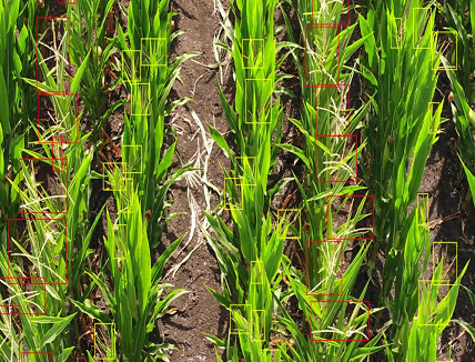
The platform provides micro-level analytics and actionable insights across the season and builds an agroecosystem that brings together all the industry players needed to improve such a vital niche, help farmers deal with their daily challenges and improve food production. With the help of AI and visual data from drones, the platform enables growers to scale their expertise on thousands of hectares, receive insights on a level of leaf and innovate production processes with a click of a button.
With a scalable infrastructure, many use cases that were previously unattainable can be created in a couple of days. Now the list of possible use cases is nearly endless and includes weed detection, crop monitoring, plant disease detection, water-logging analysis, missed tassel detection in hybrid seed production, insect damage analysis, plantation monitoring, flowering detection, precise plant stand counting, canopy analysis, weather and wildlife damage analysis, and many more. To unlock the potential of Precision Agriculture technology, Proofminder offers time-sensitive insights on a micro level rather than on a zone or field level. They developed a system that allows growers to scale their knowledge to thousands of hectares with the touch of a button and estimate, predict, and enhance everything visible in the field.

The initial missions were stand counts for sugar beet, sunflowers, and corn. Later on in the year, the system was utilized to carry out missions to map wildlife damage and identify corn tassels.
When developing algorithms, the information gathered by drones is contrasted with the actual data obtained by humans walking out into the field and physically counting and measuring in reality. There are no other means that can provide the information required, thus using this technology is the only other option.

Precision Agriculture with UgCS Software
UgCS as a flight planning software solution made a great contribution to the development of the functionality of the platform due to the variety of necessary and useful options. The ability of collaboration between a “person from the office” and the pilots in the field in case it became necessary to alter the routes while they were being carried out, having an individual server and all the team members can download the missions on their own no matter where they are located at the time as well as handling multiple drones (4 pilots working on a 100-ha field at a time) help increase speed of research.
Furthermore, with the help of UgCS the platform can create several smaller segments out of a large area. Comes in handy when flying with smaller drones instead of one large or a VTOL drone, or if you are using different types of drones for the same large mission.

“By providing micro-level actionable insights about every leaf and plant, our mission is to help growers make the agroindustry future more sustainable, innovative, and profitable regardless of the ever-changing environment. It makes the planning on the surveys much easier, and we can automate time-consuming human efforts. UgCS helps us a lot to work with the drone pilots and service, providing shortening the onboarding and decreasing the room for errors.” Norbert Havas, CEO of Proofminder
One of the key differentiators is the way they gather data on various field vegetation types. Proofminder use unprecedentedly high resolution and previously impossible use cases such as weed identification, assessing insect damage, and identifying male and female traits, now can be implemented. Additionally, they enable data extraction from fields that are inaccessible to people. This has significant importance, especially, when used in the agricultural sector, where it is sometimes difficult to reach remote areas due to a lack of resources (e.g., labor or funding).


