


Expanding the lineup of Surveying Drones & Cloud Analysis functions, contributing to further productivity improvement
Aerosense Co., Ltd. will hold the Chiba Makuhari Messe Exhibition Hall for three days from May 12th (Wednesday) to 14th (Friday), 2021. The company will exhibit at “The 3rd Construction and Survey Productivity Improvement Exhibition (CSPI-EXPO 2021) -The cutting-edge technology that will lead the next generation in one place-” held at the outdoor exhibition hall.
The Ministry of Land, Infrastructure, Transport and Tourism is promoting “i-Construction” to improve the productivity of the entire construction production system by introducing measures such as “Full utilization of ICT (ICT earthwork)” at construction sites. Furthermore, with the demand for a shift to non-contact and remote work styles in Corona, the DX (digital transformation) of construction and surveying sites based on 3D model data is accelerating.
In order to meet the needs of such times, Aerosense aims to contribute to further improvement of productivity at the site by expanding the lineup of surveying drones and data analysis functions using the cloud as follows. The contents will be exhibited together with the actual machine at. Details of these exhibited products will be unveiled at the CSPI-EXPO exhibition hall for the first time.
EXPANDING THE LINEUP OF SURVEYING DRONES
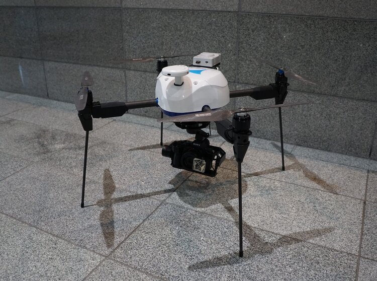
- Standard domestic drone that meets i-Construction standards:
Aerobo (Rotorcraft Drone) AS-MC03 - Supports PPK (Post-Processing Kinematic Positioning Method), which post-processes drone position information from satellites and improves efficiency by reducing markers:
Aerobo PPK (Aerobo PPK, rotary wing drone) AS-MC03-PPK - (Reference exhibit) Supports TS tracking, which automatically tracks and measures the camera position directly at the total station and improves efficiency by reducing markers:
Aerobo TS Tracking (Rotorcraft Drone) AS-MC03-TS Collaboration with Topcon Co., Ltd. - Wider area faster and more accurately:
Aerobo Wing (Vertical takeoff and landing type fixed wing drone) AS-VT01
EXPANSION OF DATA ANALYSIS FUNCTION OF AEROBO CLOUD
- PPK compatible: In addition to Aerobo and Aerobowing, data from other companies’ products (eg DJI Phantom 4 RTK) is also imported and processed.
- High-speed point cloud drawing: Large-capacity (up to several GB) 3D point cloud data can be displayed and viewed smoothly on a browser.
- SfM high-speed processing: Achieved the fastest in Japan ( according to research), processing data over 10ha in 2 hours (varies depending on the shooting environment)
Aerosense contributes to the efficiency of more diverse construction sites and surveying sites through various drones that consistently develop, design, manufacture, and sell in Japan and data analysis technology that meets needs.


