


Unveil invisible with LiDAR Technologies in Jungle Surveying & How these technologies has opened new opportunities for Archaeologists
Within recent years LiDAR technologies have been widely used to search for ancient ruins hiding under the tree canopy. The Olmec and Maya civilizations flourished in what are now Mexico and Guatemala as well as the lost Casarabe culture in Bolivia have been in a close focus for archeological studies. However, LiDAR Technologies in Jungle Surveying, particularly airborne, as a method to study tropical forests has opened new opportunities not only for archaeologists and not only in Latin America.
Unveil invisible with LiDAR Technologies in Jungle Surveying
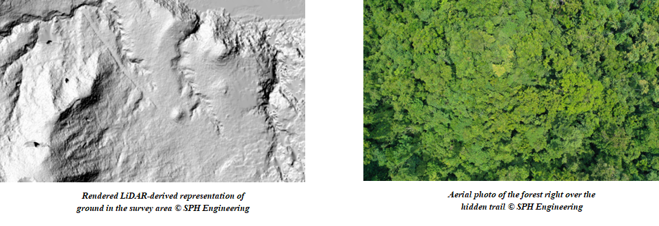
Airborne LiDAR, especially on drones, demonstrates extremely high capability to “see” through canopies of very dense jungles. In September of 2021 SPH Engineering team participated in an expedition to the Pacific region with the aim to conduct a magnetic survey of a certain area of an island in the middle of the ocean. As a preparatory step to gather elevation data the entire project area was surveyed using LiDAR mounted in a drone. Hi-resolution scanning of the area approx 3.2 x 1.2 km big took 1 full day, and actually 1 night for the data processing on a laptop computer.
‘Because of extremely dense tropical jungles and rough terrain with slopes, canyons, etc. (elevation change in the survey area was around 200m), initial expectations were to get a dense enough point cloud to build an elevation model of the ground as well as a digital surface model with grid density of around 1m,’ Alexey Dobrovolskiy, CTO at SPH Engineering, explains. ‘But after the data processing we found that even small features like fallen trees and hidden trails were unveiled in LiDAR data.’
Rendered LiDAR-derived representation of ground in the survey area allowed to note a clearly visible trail and small features on the ground which were not captured with an aerial photo of the forest right over the hidden trail.
Research Climate Change
A research team from the University of Oxford, the UK, has been investigating if tropical forests are able to adapt to a changing climate. The team goes to different sites across the tropics (Mexico, Peru, Brazil, Ghana, Gabon, Malaysia, and Australia) to collect censuses of vegetation, plant traits (e.g. characteristics of leaves such as nutrients, thickness, area), vegetation structure metrics based on LiDAR remote sensing and also spectral reflectance of the canopies with special cameras and drones. They use a UAV with the MicaSense dual camera sensor to learn the level of stress in which the trees are given their morphological and water and leaf chemistry levels.
According to Jesus Aguirre Gutierrez, Senior Researcher, NERC Independent Research Fellow, School of Geography and the Environment, University of Oxford, ‘the UAV-based data collection method is considered one of the most innovative ways of collecting spectral data from the canopies of tropical forests across large spatial extents and with high spectral and spatial resolution’. He had to plan the missions to fly the drone across the different sites in the tropical forests: ‘I needed a software that would give me flexibility to plan at any point during my fieldwork and that could take into account differences in topography, for instance, the path to fly in case the vegetation is up the mountain. UgCS by SPH Engineering allowed me to do this with high accuracy and ease and the results are also very high quality’.
Advance mapping business solutions
Business applications of airborne LiDAR surveying are popular too. For instance, CLpartner Inc, a South Korean start-up, was tasked with creating a topographical map of waterway and road construction in the jungle of the Philippines. ‘In the case of topographic surveying in the jungle, it is difficult to obtain topographic data only through image mapping because the density of trees is high. By using the LiDAR sensor, it is possible to obtain surface data under the trees, making it possible to create an accurate topographic map’, Alex Song at CLpartner Inc. comments.
Located in the Caribbean Sea, the Martinique island has a rugged mountainous terrain due to the recent volcanic activity and is overgrown with dense tropical forests. So the use of conventional survey techniques with RTK as well as drone photogrammetry are not feasible in such an area. Only drone-based LiDAR allows to perform mapping and to get terrain level under deep canopies in a fast way, saving hours or even days of manpower. Thus, drone-based LiDAR surveying allows MaTopo, a local Martinique company, to perform projects where power line scanning is necessary faster and more efficiently.
All in all, as of today to make a topographic survey or find ruins of an ancient city, there is no need to make all the way through the jungle and risk one’s life. A relatively inexpensive set of hardware and software with a total cost within 100K USD allows to obtain high-precision data even through the jungle quickly (several square kilometers per day) and relatively comfortably.


