


“AERO BOWING” CONTRIBUTES TO SAFE AND EFFICIENT MOUNTAIN SURVEYS BY DX-
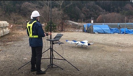
Aerosense and CTI Engineering Co., Ltd. use the vertical take-off fixed-wing drone (VTOL) “Aero Bowing”, which is consistently developed, designed, manufactured and sold by Aerosense, and has eight sabo dams. The company conducted a demonstration experiment to check at once for the first time in Japan as a drone equipped with an LTE communication function.
In the past, people went to the site to check the sabo dam in the mountains. However, in recent years, while the working population is aging, the number of disasters caused by abnormal weather is increasing, and safe and efficient inspections that do not require people to go to the site are required.
By using the Aero Bowing equipped with LTE communication function, not only does it eliminate the need for on-site inspections by humans, but it also makes it possible to take off and land from a safe place such as the foot of the mountain and check the sabo dams scattered over a wide area at once. became. It usually takes 1 to 2 days for people to enter the inspection area this time. By using this machine, it is not necessary to enter the site, and the flight time is less than 10 minutes, so the inspection time has been greatly reduced. The DX for mountain surveys using this machine is also expected to be used for disaster prevention through regular inspections and for emergency surveys immediately after a disaster that makes it difficult for people to enter the sabo dam.
Features of Aerobo Wing
- A maximum speed of 100km / h, a maximum cruising range of 50km, and a wide area of 100ha can be flown and photographed in one shot.
- Even in mountainous areas where there is a difference in elevation, it is possible to climb and descend while reducing the power consumption by turning flight.
- It is also compatible with LTE communication and high output wireless, and can fly in mountainous areas and wide areas where there is no line of sight.
[FEATURES OF AERO BOWING]
In general, sabo dams are spread over a wide area in the mountains, and the height difference of the flight path is often large in the mountains, and multicopter drones consume a lot of battery. Therefore, it was necessary to repeat takeoff and landing for each Sabo dam.
The aero bowing of the VTOL type drone is capable of wide-area surveys due to its features of maximum speed of 100km / h and maximum cruising range of 50km. In addition, even in places where there is a difference in altitude on the route, by using turning up and down after shifting to level flight, the power consumption can be significantly reduced compared to multicopter type drones. In addition, since it is a vertical flight during takeoff and landing, it is possible to take off and land from a narrow place, which is difficult with a simple fixed-wing drone. On the other hand, in a wide range of flight in the mountains, the flight route becomes invisible to the depths of the mountains, and the communication between the drone operation terminal at the takeoff and landing location and this unit is blocked by other mountains, enabling flight control and video transmission. The challenge was to lose it.
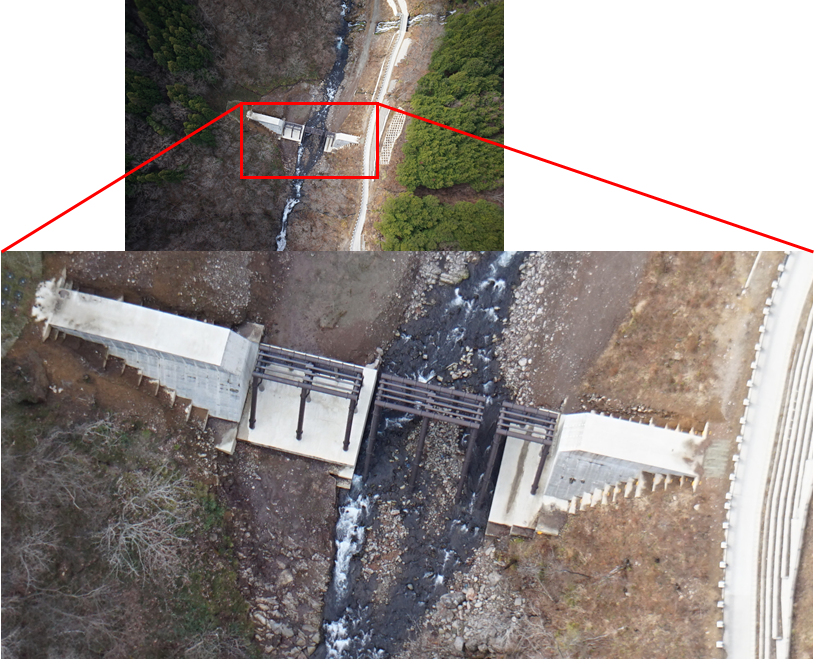
By installing the LTE communication function in the Aero Bowing, they have realized safe flight and sabo dam inspection without interruption of communication even in mountainous areas. In addition, since quantitative 3D data can be obtained as a drone photogrammetry, it is possible to obtain an accurate numerical value of the sediment accumulation ratio of multiple sabo dams in one flight.
[OUTLINE OF DEMONSTRATION EXPERIMENT]
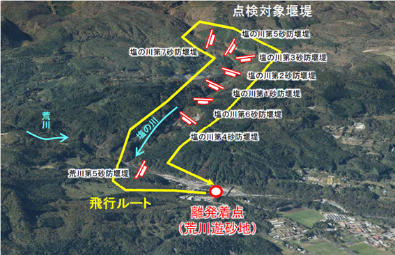
The event was held on December 10, 2021 on the hillside of Mt. Azuma in Fukushima Prefecture under the control of the Tohoku Regional Development Bureau of the Ministry of Land, Infrastructure, Transport and Tourism. The aero bow wing was flown as follows to inspect the sabo dam.
<Details of the demonstration experiment>
- Flight outline: Take off and land from the Arakawa sandy area near the foot of the mountain, and fly over eight sabo dams for inspection.
- Flight points: Even after shifting to level flight, fly deep into the mountains while raising the altitude as appropriate by combining turning climbs, and inspect eight sabo dams along a curved route that stretches for about 5 km with no line of sight.
- Flight path: Automatic flight according to a preset flight plan
- Sabo dam confirmation items: Confirmation of sediment accumulation in the sabo dam with 3D data
Aerosense aims to contribute to disaster prevention and quick recovery support by utilizing Aero Bowing equipped with LTE communication function. To see more and watch the video here on “A sabo dam inspection that took several days of dangerous mountain climbing was completed in one VTOL flight.“


