


Introduction
This blog series is intended for those who would like to understand how to improve the locational accuracy of their field data but are not sure how GPS and correction services work.
The blog below introduces some of the fundamentals of GPS—what GPS and GNSS are, how they work, and the types of errors that can impact GPS and lead to reduced accuracy.
Subsequent blog posts will dive into some of the details of what GPS corrections are and how they can be used to improve GPS accuracy, the various types of corrections services, the pros and cons of the different methods, and which method is best suited for the field data you are capturing and the environment you are working in.
The Global Positioning System
The Global Positioning System (GPS) was developed by the US Department of Defense as a worldwide navigation resource for military and civilian use. It was originally based on a system, or constellation, of 24 satellites orbiting the earth acting as reference points from which GPS receivers on the ground can use to compute their position. Today GPS is joined by other satellite constellations including GLONASS, Galileo, and BeiDou, greatly expanding the number of positioning satellites in orbit. Collectively these constellations are referred to as GNSS—Global Navigation Satellite Systems. For the rest of this blog series we will use the term GNSS in place of GPS as all modern Trimble receivers are capable of tracking multiple constellations.
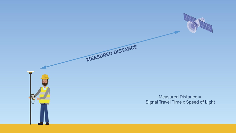
GNSS receivers work by listening to a series of specially coded messages transmitted by each satellite; a GNSS receiver on the ground can calculate how long it took the signal to get from the satellite to its own antenna. Then, to calculate the distance from the antenna to the satellite, the receiver multiplies that travel time by the speed of light. A GNSS receiver is able to make this calculation with multiple satellites simultaneously. If the GNSS receiver is receiving messages from at least four satellites, it can then triangulate its location anywhere on the surface of the earth.
What causes errors in GNSS location?
GNSS receivers need to be receiving messages, or tracking, from at least four different satellites in order to calculate a location, but this location will not be perfectly accurate. There are various sources of error that can reduce the accuracy of the calculated location.
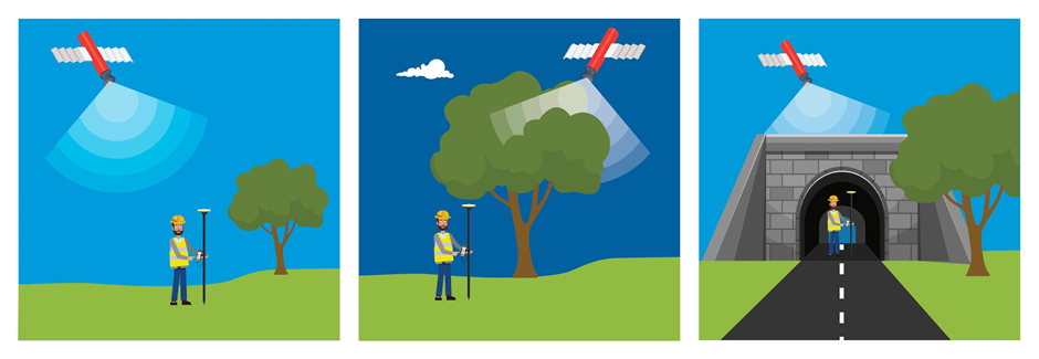
The first step in improving location accuracy, and reducing errors, is ensuring the receiver is able to track as many GNSS satellites as possible. Tracking four satellites is the minimum, but each additional satellite the receiver can track provides more messages that can be used to improve the accuracy of the calculated location. Tracking more satellites also enables the receiver to prioritize using messages from satellites that are the highest quality, or are the least impacted by errors, further improving the accuracy of calculated location. When working with GNSS it is important to try and maintain a clear view of the sky so the receiver has the best opportunity to track as many satellites as possible.
There are four main sources of error that can impact the location calculated by the receiver:
- Receiver and Antenna Error
- Satellite Error
- Atmospheric Error
- Multipath Error
1. Receiver error
Receivers and antennas can introduce errors of their own into the location calculation. Electro-magnetic interference from other components on a GNSS receiver (like a modem or display) can reduce the quality of the messages before they are received by the antenna, while the quality of the GNSS receiver and a larger antenna will have a positive impact on location accuracy. This is why a Trimble GNSS receiver is able to calculate a more accurate location than a smartphone.
2. Satellite Error
The timing of when a message is broadcast from a satellite is critical to GNSS, and so GNSS satellites are equipped with very accurate atomic clocks. Unfortunately these clocks are not perfect and slight inaccuracies in the timing of messages broadcast from the satellite can lead to errors in the location calculated at the receiver. Also the satellite’s position in space is important, but satellites can drift slightly out of their predicted orbit. This can introduce errors in the receiver when it calculates the distance between the antenna and satellite.
3. Atmospheric Error
GNSS satellites transmit their messages by radio, and since radio signals in the earth’s atmosphere do not always behave predictably, this is another source of error. The receiver makes an assumption that radio signals travel at the speed of light, and that the speed of light is a constant, but this is only true in a vacuum.
In the real world, light slows down, depending on what it is traveling through. As a GNSS signal travels to the surface of the earth, it gets delayed a little, and because the calculation of distance assumes the signals travel at a constant speed, this delay leads to a miscalculation of the satellite’s distance, which in turn creates an error in location.
Trimble receivers use a correction factor for the signal’s trip through the atmosphere, but given the number of variables, no correction factor or atmospheric model can compensate exactly for the delays that actually occur.
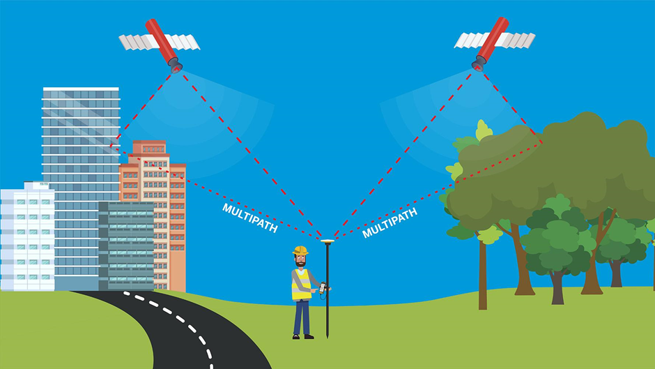
4. Multipath Error
When the signal arrives at the surface of the earth, it can reflect off obstructions such as buildings and trees, before making it to the antenna. The signal arrives at the antenna by ‘multiple paths’ which is why this type of error is called multipath error. The antenna receives the direct signal first because the direct route is always fastest, and then the reflected signals arrive later, interfering with the direct signal and giving ‘noisy’ results. Trimble antennas are designed to reduce multipath interference but it is not possible to eliminate it completely.
Eliminating Errors with GNSS Corrections
A GNSS receiver needs signals from at least four satellites to establish its location, and each of these signals has its own set of errors as described above. The satellite clocks might be inaccurate, or the satellites might not be in their predicted orbits. As the signals travel down through the atmosphere, they are deflected and delayed because the earth’s atmosphere is not a vacuum. The signals are bounced around when they meet local obstructions (creating multipath error) before finally reaching the receiver
Fortunately, satellites are so far out in space that distances on earth are small by comparison. If multiple GNSS receivers are within a few hundred kilometers of each other, the signals that reach them will have traveled through virtually the same piece of atmosphere, and will have virtually the same delays. This means receivers will typically be impacted by the same errors, excluding multipath and receiver errors. So, one receiver can measure the errors and provide corrections for these errors to the other. This process of eliminating errors is called GNSS corrections.
In the next blog we will cover how GNSS corrections work, and the different types of GNSS correction services that are available.
For more information visit Trimble Geospatial Blog Here.


